In My Footsteps
Christopher Setterlund
Trip 81: Newport, New Hampshire
September 21, 2010
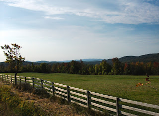
Very few things I have seen on my travels so far have been as impressive and breathtaking as my drive through Central New Hampshire. The mountains are all around you and when it is combined with the oncoming fall foliage it makes for a dreamlike experience.
 |
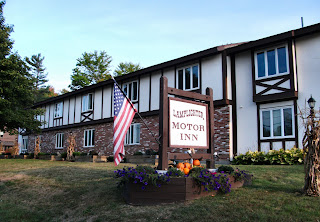
| The Pier Bridge |
 |
| The amazing view inside the Pier Bridge. |
Newport, New Hampshire, located just west of Mt. Sunapee , is the very definition of a mountain town. The drive to get there, going through the very well known Sunapee area of New Hampshire, is worthy of an article all its own. I found it very interesting that despite it being for a totally different reason Newport, New Hampshire was just as beautiful as Newport, Rhode Island. Where Newport, Rhode Island is beautiful thanks to its mansions and scenic coastline Newport, New Hampshire is beautiful thanks to its covered bridges and scenic mountains.
First settled in 1763 after a delay due to the hostilities of the French and Indian War, Newport became a very prosperous town thanks to its soil and the Sugar River. A grist mill and cotton mill were established not too long after but it is a project which never got off the ground that I find most interesting.
 |
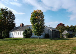
| South Congregational Church |
In 1817, inspired by the development of the Erie Canal in New York, businessmen suggested that a canal be created between the Connecticut and Merrimack Rivers. This would have begun at the Sugar River in Newport and would have used Lake Sunapee as a reservoir. For whatever reason, probably money, this proposed canal project was dropped before the first shovel was plunged into the dirt. Ironically the Newport-based Sibley Scythe Company, established in 1842, supplied the scythes that were used to clear the jungle away from the site of the Panama Canal when construction began in 1903.
The first thing I wanted to see when I arrived in Newport was one of the three covered bridges located within its boundaries. Even with a GPS  these magnificent old relics of a forgotten time were very hard to find. Luckily two of the bridges were located on the same road, Chandler’s Mill Road.
Located a mile down Chandler’s Mill Road is Pier Bridge. The 216-foot long wooden truss bridge was built in 1907 and crosses over the Sugar River. It was built to replace a wooden lattice bridge from 1871 which was used by the Sugar River Railroad. The tracks are no longer there but there is a nice, wide dirt path which will lead to the second bridge, Wright Bridge, less than a mile walk away.
 |
| Newport's Town Hall & Court House |
For the Pier Bridge there is a small dirt area where I parked, it is an easy walk to the entrance of the bridge. I have only seen one other covered bridge and that was in Vermont so standing inside this wooden masterpiece with only the sound of the birds and the soft trickling of the water below was something wonderful. I truly felt like I was alone in the world during the time I was underneath the shelter of Pier Bridge. The sunlight trickled in from all sides through the small spaces between boards. It was something that words won’t do justice to, a photo will do much better.
I did not choose to walk the .8 miles to the Wright Bridge. Looking back I should have as my treasure hunt using my GPS led me way off track, I ended up at a point where there were no markings on the GPS screen, only white. Needless to say after a few drives up and down Chandler’s Mill Road I gave up and headed to my next destination. Still, I was so happy to get to stand underneath one of only eight covered railroad bridges in the entire country.
The next stop during my time in Newport consisted of a walk down Main Street. I parked at the historic South Congregational Church, built in 1823, which stands stoically over the surrounding homes and businesses. The warm autumn day combined with the colorful leaves made this walk a pleasure, however, the places I got to see on Main Street were in a class of their own.
There is a saying that the ‘whole is greater than the sum of its parts,’ that is sort of the case with Newport’s Main Street. Yes there are many historic buildings but the entire scene as I walked along through the peaceful mountain town was something I wanted to capture and take with me when I had to leave.
There is the beautifully sculpted Golden Eagle, a replica of the eagle crafted by Stephen Hasham of Charlestown, New Hampshire which once sat atop the Eagle Hotel. It will definitely catch your eye as you pass by as it did for a small group of elementary school students who were out on a field trip on this day. Sometimes that is how I feel as well.
 |
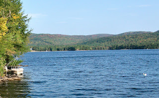
| The awe-inspiring Train Mural on Main Street. |
A few steps away is the mammoth brick Newport Town Hall & Court House built in 1886. In fact there are several brick buildings, all from around the same time period, 1880’s and 1890’s which stand along Main Street. The really neat thing about them, and this is the case in other towns I have visited, is that they each have names, usually on a smoky gray background. I saw the Lewis Block, DeWolf, and Wheeler’s Block as I walked. I can only assume they were named for those who put up the money to have them built.
One amazing sight, off the beaten path, along the side of the Johnson Block building is ‘The Train Mural.’ It is an awe-inspiring hand painted depiction of the four seasons of New Hampshire along with some well known sites from the town of Newport. This is a perfect way to get a taste of what this town is really all about if you do not have the time to walk. I have been unable to find any information as to how old the Train Mural is, or who painted it, but they deserve great thanks for creating something so beautiful.
Newport, New Hampshire is every bit as beautiful as its counterpart in Rhode Island. From the covered railroad bridges to the trip to a simpler time that my walk on Main Street provided it is a town that I will not soon forget. I hope everyone gets the chance at some point to visit this classic mountain town and to take in all of its beauty; it is worth any length of time to get here. Have fun and happy traveling!
My first book, In My Footsteps:
A Cape Cod Travel Guide, is now available at SchifferBooks.com,
BarnesandNoble.com, and Amazon.com,
soon to be in stores everywhere! Follow me on Twitter!
Directions: Pier Bridge: From I-89 headed north take Exit 12 for Rt. 11. Turn left at Rt. 11, follow it 11 miles, turn left at N. Main Street. Take 3rd right onto Rt. 103, follow 3 miles, turn left at Chandler’s Mill Rd., bridge is 1 mile up on right.
Main Street: From I-89 headed north take Exit 12 for Rt. 11. Turn left at Rt. 11, follow it 11 miles, turn left at N. Main Street, there is parking on the right side of street.
References: Newport, NH.net


