Pages

Showing posts with label portsmouth. Show all posts

Wednesday, November 1, 2023

In My Footsteps Podcast Episode 118: Yarmouth's Sandy Pond Club, Birthday Greatest Hits, 1980s Fast Food Fails, Portsmouth NH, Great Emu War(11-1-2023)


It's Birthday Week on Episode 118 of the podcast!
There's a cause for celebration as I make another trip around the sun. What better way to reminisce than by looking at how a birthday evolves and changes as we age? Oh, and also there will be a makeshift Top 5 as I share some of the best(worst) birthday memories!
From a celebration today, to celebrations in the past, it'll be a fond, if somewhat hazy, look back at wild times on Cape Cod in the 1970s as we check out the story of the brief but spectacular existence of Yarmouth's Sandy Pond Club bar.
This week's Road Trip features one of my absolute favorite places in all of New England, Portsmouth, New Hampshire. It will be tough to narrow down all there is to see and do there into a manageable segment, but we will get it done.
As a kid in the 1980s, no birthday celebration was complete without a trip to the drive-thru of your favorite fast-food establishment for dinner. This week's Top 5 is the other side of the coin as we look at the ambitious or downright odd menu items that became legendary fast food fails in the 80s.
There will be a brand new This Week In History and Time Capsule featuring the strange but true story of Australia's Great Emu War.
For more great content become a subscriber on Patreon or Buzzsprout!

Helpful Links from this Episode


Tuesday, October 13, 2020

In Their Footsteps: New England History - The Smuttynose Island Ax Murders

    On a cold night, on an island isolated by miles of ocean, a pair of gruesome murders took place. Two women lost their lives at the end of an ax while a third survived to finger the perpetrator. The culprit was caught, tried, convicted and put to death. Case closed. Or was it? What really happened on the tiny island of Smuttynose off the New Hampshire coast nearly 150 years ago? Here is the story, as it is known, of one of New England's creepiest unsolved mysteries.

    Fishing and New England go together like peanut butter and marshmallow fluff. Though not as thriving of an industry today it was the life-blood of the New England coast for centuries. Men flocked to such fishing areas with their families in tow hoping to create a better life. Though whaling had died down by the latter half of the 19th century fishing still was prosperous. The fishing industry played a large part in the crime that occurred.

    In 1868 a young couple, John and Maren Hontvet arrived in America from Norway. They found their way to the tiny island of Smuttynose located seven miles off of the coast of Rye, New Hampshire.  Part of the Isle of Shoals technically the island is considered part of York County, Maine. The couple rented a red, two-story duplex on the island and were the only year-round inhabitants of Smuttynose. John captained a schooner, the Clara Bella, and eventually brought his brother Matthew in to help him with the fishing. In 1871 Maren's sister Karen arrived from Norway and took up a job at the nearby Appledore Hotel on the neighboring Appledore Island.

    Needing another hand to help with the business John brought in a down on his luck young Prussian fisherman Louis Wagner into the fold in early 1872. Though he became very close to John and Maren others were distrustful of Wagner. He seemingly always fished alone and his past remained shrouded in secrecy. Nevertheless John Hontvet considered Wagner like family and invited him to stay on the other side of the red duplex in April 1872. Wagner's tenure in the Hontvet home ended shortly after the arrival of Maren's brother Ivan Christensen and his wife Anethe.

Louis Wagner (Edmund Pearson, Public Domain)


    John Hontvet now had more than enough help on the Clara Bella and so it was decided that Louis Wagner would take a job on another schooner, the Addison Gilbert. He departed Smuttynose in November 1872 with seemingly no ill will toward his friend and former employer. However that was not the case. Wagner had been forced to move from the relative comfort of the Hontvet's home to a flop house in a seedy part of Portsmouth, New Hampshire. His fortunes only worsened when the Addison Gilbert sunk with all of Wagner's belongings on board. This left Wagner desperate for money. An unfortunate series of events led to one of the most horrific crimes of the 19th century.

    Wagner was at the docks when John Hontvet and his crew came ashore on the Clara Bella on March 5, 1873. They were waiting for a train carrying a shipment of bait from Boston. The train was running late forcing John, Matthew, and Ivan to wait on the docks rather than return to their significant others on Smuttynose. Wagner made it a point to ask John if the women would be along on the island. When he was told yes it gave Wagner an idea to row his way out to the island. He figured in the dark of night the three women would all be asleep and Wagner could sneak in and steal all he could to recoup his losses from the sinking of the Addison Gilbert.

    Wagner stole a dory and slipped away toward Smuttynose around 9pm. He rowed a considerably longer route south around a pair of the Isles of Shoals islands to avoid detection. Around midnight Wagner came ashore at Smuttynose and all was dark and quiet. However upon entering through the kitchen he was startled by the family dog as well as Maren's sister Karen who had been sleeping on a cot.

    As Wagner struggled with Karen, Maren and Anethe, who had been sleeping in a nearby bedroom, came to investigate. Maren was able to get Karen away and locked in the bedroom which left Anethe at the mercy of Wagner. She ran outside into the cold night air as Wagner grabbed an ax and pursued her. Anethe was able to identify Louis Wagner by name just moments before he killed her with an ax blow to the head. He then turned his attention back to the bedroom with the two other women.

The purported murder weapon now on display at the Portsmouth Athenaeum (Murderpedia.org)

    Wagner battered his way inside. Maren tried to get the barely conscious Karen to flee with her. Unable to rouse her she jumped out of the window and into the night. Wagner's blow with his ax did not kill Karen and he decided to finish her off by strangling Karen to death. Maren hid with the family dog in the rocks while Louis made himself a quick meal in the kitchen. After eating he resumed his search outside for Maren. Unable to find her he decided to leave the island and assume the cold would kill her. The island of Smuttynose was dark and quiet again as Wagner returned to Portsmouth.

    Louis fled Portsmouth via train to Boston. Maren survived the night and was taken to safety at Appledore Island to be treated for frostbite. The Clara Bella made it to Smuttynose at 10am on March 6th and the lives of the men aboard were changed forever. Wagner was identified as the murderer. His assumption that Maren had died from exposure proved to be his undoing. He returned to his old boarding house in Boston and his other old haunts. Wagner was quickly arrested by police without incident.

    Louis Wagner was sent to Saco, Maine for trial. Maren's first-hand testimony was so overwhelming that he was convicted and sent to prison in Thomaston, Maine to await execution. He escaped at one point yet was recaptured in three days as he made it a point to tell people he was a famous killer. Wagner was executed by hanging on June 25, 1875 all while proclaiming his innocence. In the aftermath of the murders John and Maren moved to Portsmouth, Ivan returned to Norway while Matthew's fate is unknown. Karen and Anethe Christensen were buried in Portsmouth's South Cemetery. The red duplex on Smuttynose was ransacked by ghoulish tourists taking pieces of blood spattered wood and other trinkets before the home ultimately burned in 1885.


Smuttynose Island in 2006 (Shoaler at English Wikipedia) 

    Despite the seemingly air-tight case against Louis Wagner of robbery and revenge against John Hontvet there is still a shred of doubt as to his guilt. Questions arose of how Maren could survive the cold night in night clothes, how Louis could row those many miles out to and back from Smuttynose, and how he was convicted purely on circumstantial evidence. The police were so sure they had found their man that the case was closed after Wagner's capture. There may be small seeds of doubt however it seems overwhelmingly likely that Karen and Anethe Christensen met their demise on Smuttynose at the hands of Louis Wagner.

    Today Smuttynose Island is privately owned though people are allowed to walk the grounds during the day. There is a marker and some rocks denoting where the red duplex once stood. There is nothing else on the tiny island left as a reminder of that terrifying March night nearly 150 years ago. Though for those looking for a chance to get up close to the Smuttynose murders the ax purportedly used by Wagner is on display at the Portsmouth Athenaeum.


For more on the Smuttynose Murders: Smuttynose Murders.com
-------------------------------------------------

My first eBook in 10 years, In Their Footsteps, featuring the interesting stories of Cape Cod's history, is on sale at Amazon.com. 


Thursday, November 10, 2011

In My Footsteps: Trip 126: Kittery, Maine


In My Footsteps
Christopher Setterlund


Trip 126:  Kittery, Maine
October 5, 2011


Fort McClary
            Although it is probably known more for its outlet shops Kittery has a strong historical significance as well.  The oldest town in Maine was originally settled in the 1620’s and became a town in 1647.  Ironically when most towns in the Colonies were being named for towns in England Kittery was actually named for a house.  It was named for the Manor of Kittery Court in Devon, England.  That home still stands to this day.  Of course I am not one to tell visitors to pass up the Kittery Outlets.  Still, after paying a visit to the acres of shops spread on both sides of Rt. 1 there are many other interesting things to see.
The view from inside the Block House.
            I started off my time in Kittery with an amazing old fort.  Fort McClary sits on the northern shore of Portsmouth Harbor.  There is a panoramic view of Portsmouth Lighthouse, Fort Constitution, and Whaleback Lighthouse along with many boats in the harbor during the warmer seasons.  The first fortifications on the site dated back to the late 17th century and were erected by wealthy landowner Sir William Pepperell.  The fort itself was built in 1808.  It fell into severe disrepair in the early 20th century.  The state of Maine purchased the fort and the land in 1924.  The badly damaged buildings were torn down.  The surviving buildings including the Block House were repaired in the 1980’s.
            Unlike many of the forts I have visited I was actually able to go inside one of the main buildings.  The Block House, a white hexagonal building built in between 1844-46, was wide open.  It now serves as a museum.  The view from up inside the Block House is incredible.  The vantage point must be more than fifty feet above the water level if I had to guess.  I took my time and enjoyed the views before leaving one fort behind, there was another one that I needed to visit later. 
Rice Public Library
            In between forts I took in some of the other sites that Kittery had to offer.  Although I don’t frequent them I am fascinated by how many public libraries are housed in amazing looking buildings.  That is the case with the Rice Library on Wentworth Street.  The library building looks much like ones I have seen in Easton and Fairhaven, Massachusetts.  The Rice Library has some of the same styles as many other Henry Hobson Richardson buildings despite not being created by the famed 19th century architect.
            I was particularly excited about my visit to Fort Foster.  Located on Gerrish Island in Kittery this historic site has more than just a fort.  During my trip to Portsmouth, New Hampshire’s Fort Constitution I had noticed another lighthouse located across the harbor.  That was Whaleback Lighthouse and I knew I needed to pay it a visit during a future trip. 
Whaleback Lighthouse on the left at Fort Foster.
            On this day the gates to Fort Foster were closed so I had to park outside and walk in.  Also it had been a beautifully sunny day but dark clouds had rolled in and it began to rain heavily.  I had been planning my Kittery trip for months so a little rain, or a lot of rain, was not going to stop me.  Plus the skies were still mostly blue which made me believe that a rainbow would be possible once the rains stopped.
            People were fleeing the rain while I walked out.  The fort was built in the 1870’s making it the last ‘old’ fort built in the area.  As the rain was still falling I made my way out onto a very long pier.  It was here that I got the closest view of Whaleback Lighthouse.  The fifty-foot tall structure was built in 1872.  The Whaleback name refers to a jagged stretch of rocks, a continuation of Gerrish Island completely underwater at high tide.  Though it is often considered a New Hampshire lighthouse it is located about 1,500 feet into Maine’s waters.
The rainbow which came out while at Fort Foster.
            There is also a unique house situated on some rocks near the lighthouse as well but I was unable to find any information about its significance.  It was while I was standing out on the pier that the rain let up and the sun came back out.  Sure enough a rainbow began to form.  I was able to see the entirety of the rainbow from where I stood.  For a short time there was even a second rainbow which formed.  It made my walk out there in the rain worth it.
            I had an awesome time in Kittery.  The pair of old forts were just what I was interested in seeing.  I highly recommend checking them out even if you decide to spend most of your time shopping at the Kittery Outlets.  The oldest town in Maine has so much to offer and I am so glad I got to see it.  Have fun and happy traveling!

For more In My Footsteps items follow my Twitter Feed, view more photos at the In My Footsteps fan page on Facebook, or visit my homepage at ChristopherSetterlund.com.   Thanks for reading!

Directions:  Fort McClary:  Take I-95 N through New Hampshire into Maine.  Take Exit 2 to merge onto Rt. 236 S.  At the rotary take the 3rd exit to stay on Rt. 236.  Follow it 1.1 miles, continue onto Whipple Rd., continue onto Pepperrell Rd.  Follow it .5 miles, the fort is on the right.
            Fort Foster:  Take I-95 N through New Hampshire into Maine.  Take Exit 2 to merge onto Rt. 236 S.  At the rotary take the 3rd exit to stay on Rt. 236.  Follow it 1.1 miles, continue onto Whipple Rd., continue onto Pepperrell Rd.  Follow it 1.5 miles, continue onto Tenney Hill Road.  Continue onto Brave Boat Harbor Rd., follow it .2 miles, turn right onto Gerrish Island Rd.  Turn right onto Pocahontas Rd., follow it 1.1 miles, keep right at the fork in the road.  The fort and lighthouse are straight ahead.

            Fort McClary.org
            North American Forts - Fort Foster

Sunday, August 14, 2011

In My Footsteps: Trip 122: Portsmouth, New Hampshire


In My Footsteps
Christopher Setterlund


Trip 122:  Portsmouth, New Hampshire
May 25, 2011


            There are some cities and towns that I have visited where I have had to look hard to find beautiful and historic places and things.  Then there are others that practically scream history from the moment I arrive; Portsmouth, New Hampshire is one such place.  For me it seems like the moment I cross the border into New Hampshire it is like stepping into an entirely different world.  On this day it went from being cloudy and gray in Massachusetts to immediately sunny when I entered New Hampshire.  The rolling green hills I saw once I got off the highway in Exeter made me realize this was going to be a really fun day.
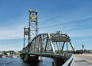
The Memorial Bridge leading to Badger Island.
            Upon entering historic Portsmouth the first spot I headed for was an old brick building called the Warner House which was originally built in 1716.  It is the oldest brick mansion in New England but it was also being worked on at the time.  This meant that standing and staring at it was a little pointless.  However, since I had paid the parking meter I had ample time to walk around Daniel St. which is really close to the Piscataqua River.  It is here that the Memorial Bridge leads drivers out to Badger Island in Kittery, Maine.  I found it really cool that Maine was so nearby.
            The next place I visited blew me away, and I must confess that it was not even on my agenda during my trip.  I happened upon Prescott Park, named for long-time resident Josie Prescott, while parking my car across the street from the Strawberry Banke Museum.  The museum was put on hold once I saw what lay at the end of a brick walkway.
Prescott Park
            I could hear the splashing of water and walked in on a simply stunning garden scene.  It reminded me immediately of the rose garden at Lynch Park in Beverly, Massachusetts.  That was one of my favorite places I had been to so experiencing a bit of déjà vu at Prescott Park was most welcomed. 
            It was such a beautiful and relaxing spot that I hardly knew where to start taking photos.  I made my way around the small rectangular garden lined with trees and round brick water fountains wanting to stay there as long as I could.  This area known as the ‘formal garden’ has been said to give the feeling of a ‘park within a park’ and that is true; it is like its own world.  I walked around this area some more and then ventured out into the rest of Prescott Park which overlooks the Piscataqua River.  There are also art shows and concerts on the grass at Prescott Park during the summer months where many well known artists and musicians come to play.  I recommend taking a lot of time here to enjoy the scenery.
Entrance to Fort Constitution
            Once I was done falling in love with Prescott Park I went to find another of my favorite things, a lighthouse.  I actually found two.  Portsmouth Harbor Light is located on the ground of the Coast Guard station but can be seen from the neighboring Fort Constitution.  This ‘setback’ actually made it even more fun as I got to visit another historical spot while viewing the lighthouse.
            Fort Constitution was originally known as Fort William and Mary until the land was given to the United States by New Hampshire in 1791.  It was repaired and renamed.  I found it neat that in order to get to the fort grounds you must go through the Coast Guard area.  To accomplish this there is a blue line that you must walk to get there, anything else is off limits to civilians.
            Portsmouth Harbor Light is one of the oldest stations in the country.  Established in 1771 it was the tenth of eleven lighthouse stations built prior to the American Revolution.  That one was wooden; the current lighthouse was erected in 1878.  There are plenty of views of this lighthouse though the walls and buildings of the Coast Guard station block a clear shot for photography.  That did not deter me as I found a way, a dangerous way, to get a clear shot.
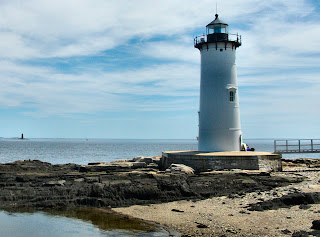
Portsmouth Harbor Light with Whaleback Light on the left.
            It just so happens that you can get an unobstructed view of Portsmouth Harbor Light by hanging out of one of the small windows of Fort Constitution which sit at ground level.  The problem is that there is nothing to hang onto and it is a nearly twenty foot drop to the rocks below.  This is why I would never suggest any traveler attempt the same; just enjoy the safer view with the buildings and wall in the way.
            Located to the left of Portsmouth Harbor Light from Fort Constitution is Whaleback Lighthouse which sits across the border in Kittery, Maine.  I got a second look at this far off lighthouse when I visited Fort Stark located south of Fort Constitution.  It is one of seven forts that were built to protect Portsmouth.  Fort Stark was built in the time between 1890-1920 however no shots were ever fired in anger from this site.  I got a cool sneak peak inside the Battery Hays building since one of the three sets of metal doors was opened.  There was nothing of consequence inside but it was still neat to see inside.
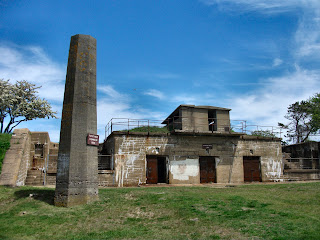
Battery Hays building at Fort Stark
            From atop the Battery Hays building I was able to get a great view of the boats sitting in the marina near the Wentworth By the Sea Hotel & Spa, one of the last remaining Gilded Age hotels.  The ‘Gilded Age’ being the time of the late-19th century.  When I turned around I got another view of the previously mentioned Whaleback Lighthouse, it was a magnificent area but then again everything I saw in Portsmouth was magnificent.
            As soon as you enter the borders of Portsmouth you know you have arrived somewhere special.  A simple walk along the historic streets near the Piscataqua River will give you the feel while visiting Fort Constitution and Fort Stark make the historical significance quite apparent.  Of course stopping to relax and maybe enjoy lunch at Prescott Park might be my favorite way to enjoy Portsmouth, but everyone can decide for themselves.  Have fun and happy traveling!

   My first book, In My Footsteps: A Cape Cod Travel Guide, is now available at SchifferBooks.com, BarnesandNoble.com, and Amazon.com, in stores everywhere!  Follow me on Twitter!  For more In My Footsteps items follow the In My Footsteps fan page on Facebook, or visit my homepage at ChristopherSetterlund.com.   Thanks for reading! 


Directions:  Prescott Park:  From I-95 N take Exit 3 for Rt. 33; turn right, follow 1.8 mi., continue onto Middle St., follow .8 mi., turn right onto State St.  Turn right onto Atkinson St., take 1st left onto Court St., turn right onto Marcy St.  Park will be on the left.
            Portsmouth Harbor Light:  From I-95 N take Exit 3 for Rt. 33; turn right, follow 1.8 mi., continue onto Middle St., follow .8 mi., turn right onto State St.  Turn right onto Pleasant St., continue onto Marcy St.  Slight left onto NH 1-B South, follow 2 mi., turn left onto Wentworth Rd., slight right onto Sullivan Ln.
            Fort Stark:  From I-95 N take Exit 3 for Rt. 33; turn right, follow 1.8 mi., continue onto Middle St., follow .6 mi., turn right onto Miller Ave., continue onto Sagamore Ave.  Turn left onto NH 1-B, follow 1.8 mi., turn right onto Wild Rose Ln., follow to the fort. 

References:  Warner House.org
            Prescott Park.org
            City of Portsmouth.com
            Portsmouth Historical Society