Pages

Monday, April 26, 2010

In My Footsteps: Trip 43: Yarmouthport, Mass. - Part Two


In My Footsteps
Christopher Setterlund

Trip 43: Yarmouthport, Mass. – Part Two
April 15, 2010

            Nothing beats Route 6A in the spring.  The warm, sweet smelling air coupled with the blooming trees and flowers gives every site the appearance of a painting or postcard.  I decided to venture back over to Yarmouthport to check out some places missed during my first article.  I also wanted to find out just how people spell Yarmouthport.  Is it with the space, or without?  According to the highway signs near Exit 7 it is without the space, so I am going with that way until further notice.
            It was a pleasant change to be able to take a stroll along the historic sidewalks of 6A in Yarmouthport while it was sunny and warm.  Most of my other trips had taken place during the dead of winter so I really appreciated this day.  There are plenty of great places to park to get out and walk along 6A, I chose the small parking area of the Kelly Chapel, located behind the Post Office.  I walked east a little ways, deciding to start from the First Congregational Church of Yarmouth(left) and work my way back. 
            The First Congregational Church, which sits on Zion Hill overlooking the Yarmouthport Village Store, was first gathered in 1639 coinciding with the town’s founding.  The current church was built in 1870 due to the increasing need for a larger building to house all of the worshipers in the town.  It has a majestic quality to it, especially after dark when the face of the church is lit up by a large spotlight.  It is the prefect start to a spring stroll. 
            As you walk along this area of Rt. 6A it is important to keep your eyes open for black and gold plaques featuring a sailing ship.  It is along this stretch of road that there are fifty-three such plaques; these make up the ‘Yarmouth Captain’s Mile.’  It is amazing when you do spot all of the plaques adorning the fronts of homes, to realize that so many sea captains once lived in such close proximity during the 18th and 19th centuries. 
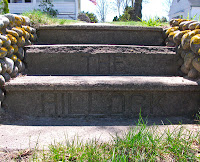
One such house that intrigued me was the Captain Thomas Ryder House located next to the Yarmouthport Library.  The home itself is beautiful, sitting on a modest hill with a large wraparound front porch.  It was after I had snapped a few shots up close that I noticed something odd.  On the three steps leading from the walkway to the street there were words.  The words read ‘The Hillock.’(right)  I do not know what this meant, or how many people that pass by the steps ever notice them, but it makes for a neat mystery that I am trying to figure out.
            Located across from the post office is the Winslow-Crocker House(left).  Originally built in 1780 this house is a great place to check out just because of the story of how it got to where it currently stands.  The house sat in West Barnstable but was bought and moved by Mary Thacher in 1936; she subsequently used the house to showcase her collection of colonial furniture, hooked rugs, ceramics, and other antiques.  Set back from the road the house has a spacious yard, it can make you feel as though you are looking at this house when it was originally built despite the fact that it is not its original location.  The Winslow-Crocker House is available for tours and operates as a museum where many of Mary Thacher’s antiques are still on display.
            Normally I would not consider a bookstore to be an historic spot that needed to be visited.  When it is the Parnassus Bookstore(left), a Cape Cod landmark, an exception can be made.  Located just before the curve that forks off toward Dennis Pond the Parnassus Bookstore has been a part of Yarmouthport for nearly 200 years.  Before it was a bookstore the building housed Knowles General Store.  Inside you will find shelves of old and rare books, many of which have to do with Olde Cape Cod.  Outside there are more shelves of books underneath an awning, I found it a bit odd to have books located outside of the building itself but I believe that it only adds to the charm of this spot.  Even if you are not a lifelong Cape Codder I recommend taking some time to look through the rare books and discover a lot of what made the Cape what it is today.
            After taking this stroll along Rt. 6A the only spot to end it is at the Hallet’s Store(right).  Established in 1889 by Thatcher Taylor Hallet this Cape institution was originally a pharmacy complete with soda fountain and lunch counter.  Now owned by the great-great grandson of Thatcher, Hallet’s is still serving ice cream and sodas as well as doubling as a museum.  The 121-year-old shop still has all of its original fixtures inside; the fact that they still serve sandwiches, ice cream, and sodas as well makes you feel as though you just sat down in the late 19th century.  The dedication to retaining that authenticity is what makes Hallet’s special.  It is open from April through November.     
            Whether you choose to spell it Yarmouthport or Yarmouth Port there is one thing that can be agreed on, a trip down the amazing Route 6A in the spring is something that locals and far off visitors alike will enjoy.  I make this drive a few times per week and still marvel at the fact that so much history sits so close to me.  So visit the Winslow-Crocker house, read a few passages at Parnassus, grab some ice cream at Hallet’s, and if anybody knows what ‘The Hillock’ means on the steps in front of the Thomas Ryder House please let me know.  Have fun and happy traveling!
Directions:  From Rt. 6, take Exit 8 and head north on Union Street.  Turn left on Rt. 6A and follow it for about ¾ mi., it is up to you where to park and start to enjoy the sites along 6A.
ReferencesParnassus Books
            Yarmouth Historical Society
            Edward Gorey House.org
            Hallets Store

Tuesday, April 20, 2010

In My Footsteps: Trip 42: Easton, Mass.


In My Footsteps
Christopher Setterlund

Trip 42: Easton, Mass.
April 7, 2010

            There are some spots that are obvious destinations in Massachusetts such as Cape Cod, Plymouth, and Boston.  There are other spots that are hidden gems that should be made destinations.  One such place is a little town just east of Brockton called Easton.  When choosing my destinations for my travel articles I look for towns with history and natural beauty, Easton has both.
            First settled in 1694 by Clement Briggs, who had a home built near the present-day Easton Green, the town was mainly a Native American hunting and burial ground until 1713.  During King Philip’s War, Metacom, King Philip himself, used Easton as a headquarters.  The most prominent name, however, associated with Easton is that of the Ames family.  Many buildings in Easton feature the Ames name.  Who are the Ames family?
            Oakes Ames was a politician born in Easton.  He served in the House of Representatives for Massachusetts from 1863 to 1873.  He is also seen as the most important person in the completion of the Union Pacific portion of the United States Transcontinental Railroad.  He was asked to take over the Union Pacific portion by President Lincoln who was busy dealing with the Civil War.  The railroad was completed in 1869 where the ‘Golden Spike’ was hammered home at Promontory Summit in Utah. 
            Oliver Ames was the son of Oakes Ames.  He was also a politician and was Governor of Massachusetts from 1887 to 1890.  Easton’s high school is named Oliver Ames High School in his honor.  However it is his father Oakes Ames who has the more amazing building serving as a memorial to his work.     
            The Oakes Ames Memorial Hall(above), located in the historic district of North Easton, is a truly spectacular piece of architecture.  Built between 1879-1881 the hall served as a gift from Ames’ children to the town of Easton after his disgrace of the Credit Mobilier of America Scandal during the late 1860’s.  It was meant to be a Town Hall but ended up being more of an informal meeting house for private groups.  It stands up on a hill overlooking the historic districts Main Street and Lincoln Street and has a pinkish-gray color.  Though rarely used today this building is more than just eye-catching, upon seeing it I felt the need to stand under the immense arches and take in the hot sunny day from the shade.
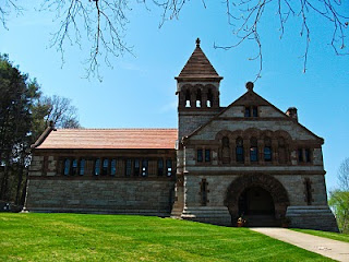
            Two other buildings adjacent to the Ames Memorial Hall have an amazingly similar look to it, almost as if they were its children.  The reason for this is that all of the buildings were designed by famed 19th Century architect Henry Hobson Richardson.  Directly across the street from the Hall is a former post office located at 66 Main Street which is now a public building.  Located to the right of the Hall is the Ames Free Library(right).  Serving as the town’s library this building has a beautifully large front lawn.  It has stayed virtually untouched since the children’s wing was built in 1931 as a gift from Fanny Holt Ames to honor her husband William H. Ames.  With a renewed interest in the architecture of H.H. Richardson the library has become a destination for students from all across the country and abroad.  Located behind the library is what can only be described as a sizeable restoration project. 
After purchasing the adjacent Queset estate and the property behind the library the Ames Library Trustees have taken it upon themselves to restore the incredible Italian Garden.  Developed by Winthrop Ames in 1911 this garden was once a shining example of the Country Place Era in the United States.  It had fallen into severe decay and disarray but as I stood alongside the grounds I could not help but be impressed by the work these Trustees have put in.  The former Italian Garden is a sight to see even in this early stage of restoration.   
On an island in between Main and Lincoln sits a most unusual piece of historical beauty.  It is called The Rockery(right) and my words will not fully describe exactly what it is.  Created by noted American landscaper Frank Law Olmstead, The Rockery was built in 1882 as a memorial to the citizens of Easton lost during the Civil War.  The memorial itself consists of systematically piled boulders and an archway very similar to those seen in the Ames Memorial Hall.  Unstable and falling apart over the years The Rockery has been fortified and restored to its original dimensions.  There is a dirt walkway atop the memorial that gives one some spectacular views of the North Easton historical district.  I cannot stress enough the need to physically see this most unusual yet beautiful piece of history.
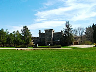
Along the border between Easton and Sharon sits Borderland State Park.  An amazing array of natural beauty it is also surprising to find out that the state park is a National Historic Site.  Once I stepped onto the grounds I found out the reason though.  It all comes back to the Ames family once again.  The 1,782 acre Borderland State Park has a Frisbee golf course, gigantic open fields, horseback riding, and the picturesque Leaches Pond.  However, this land, purchased by Oakes Ames, son of Governor Oliver Ames, in 1906 contained a surprise for me, a three-story, twenty room surprise.  The Ames’s mansion(left) still stands along the edge of a large green field and is virtually unchanged inside and out.  It is magnificently out of place.  The home is available for tours on the third Sunday of the month between April and November.  Leaches Pond which is only a short walk from the mansion was used for scenes of the film Shutter Island.  There is a stone lodge along the shore where the scenes were shot.   
Easton was a spot on my list of places to see for a while and when I finally got the chance it absolutely lived up to my expectations.  It had the amazing historical sites like the Ames Memorial Hall and The Rockery.  These were made more enjoyable by the peaceful ambiance of the historic district.  Borderland State Park is a place that could be visited for weeks in a row and you’d probably find spots yet unseen.  Easton is a hidden gem in Massachusetts that needs to be a destination for all people who enjoy beautiful scenery, historic sites, and small town charm.  I highly recommend taking a day trip here to take it all in.  Have fun and happy traveling!    
DirectionsNorth Easton Historic District:  From I-495 heading north take Exit 7A for Rt. 24 north.  Take Exit 17B to merge with Rt. 123.  Turn right onto Rt. 138, follow 1 mile turn left at Main Street.  Take a slight right to stay on Main Street.  There is a small parking area in front of The Rockery.  From here it is a short walk to Ames Memorial Hall and Free Library as well. 
Borderland State Park:  From I-495 heading north take Exit 7A for Rt. 24 north.  Take Exit 16B to merge with Rt. 106, follow 5 miles and turn right at Poquanticut Ave.  Turn left at Massapoag Ave, follow 2 miles, park will be on right.
            Borderland State Park
                Easton, Mass. - Official Site

Sunday, April 18, 2010

In My Footsteps: Trip 41: Brockton, Mass.

-->
In My Footsteps
Christopher Setterlund

Trip 41: Brockton, Mass.
April 7, 2010

            Brockton, nicknamed the City of Champions for its connection to boxing legend Rocky Marciano.  It may be all of that to the average visitor but to me it is a lot more than that.  To me Brockton is where a large part of my family lived and came from.  This trip was just as much about seeing where my mother and grandparents lived and spent time as it was to see the historical sites and some natural beauty that lies within the city’s limits. 
            Originally called part of Bridgewater, and then North Bridgewater, until 1874 Brockton got its name from Isaac Brock.  Brock was a British soldier nicknamed the ‘Hero of Upper Canada.’  He fought and died during the War of 1812 at the Battle of Queenston Heights in present-day Ontario, Canada.  The feel as you drive through the downtown area of Brockton is that of a once thriving industrial center.  There are many old brick buildings that once housed successful businesses more than a hundred years earlier.  They still stand as a throwback to Brockton’s history.  One such building is the brick building that once belonged to the Brockton Edison Company Old Power Station.  Now housing the Metro South Chamber of Commerce(left), the building was constructed in 1883.  The power station was Thomas Edison’s first model of a complete power station.  The main reason that this incredible first in modern power has been overlooked is that Edison felt that it was much more important to achieve a similar three-wire electrical generation in New York City.  The Brockton Edison plant was never fully appreciated during its initial run but its pace in American history cannot be overlooked.
            In the same vicinity as the Brockton Edison building lies Brockton’s City Hall(right) which is a magnificent sight.  It was originally built in 1892 and sits overlooking an area called Brockton Common.  The Common is a small area with benches and a few rows of trees, it is a gathering place in the center of the busy city.  City Hall itself appears to be much more modern than the surrounding buildings despite being nearly 120 years old, the brick design looks like a second skin.  The monument to the Brockton Firefighters who perished in the Strand Theater fire in 1941 is an eye-catching statue and is only the first evidence of the importance of Brockton’s firefighters.  On Pleasant Street lies the Central Fire Station(below).  Built in 1884 it is an historic brick building that is a part of the National Historic Register.  
            Brockton may be the sixth largest city in Massachusetts but there are spots where peace and quiet reigns supreme.  One such place is D.W. Field Park, a 700-plus acre park that is used by frazzled city folk as a way to unwind.  Daniel Waldo Field donated the land during the 1930’s and was a well known contemporary and combatant of Thomas Edison.  Field believed that any city needed an abundance of natural beauty for its people to truly be happy.  He also believed that Edison would disrupt that upon his arrival.  His donation of the 700-plus acres is living proof of D.W. Field’s beliefs.
            The park is a great way to spend a sunny day.  There are several ponds and nearly seven miles of paved roads around the park.  Porter Pond is split by Oak Street into Upper and Lower sections.  Lying next to the park is the D.W. Field golf course as well as a tremendous stone observation tower simply called the Central Tower(left).  The tower, ponds, and golf course wrap together and make an incredible scene that seems to be so far removed from the downtown area but yet it fits right in perfectly.
            After all of the sites had been seen it was time for me to discover the areas that were important to my family in Brockton.  I enjoyed the drive out to a beautifully quiet section of Brockton on West Elm Street where I found the house my mother grew up in.  According to her and my grandparents it still looks the way they remember it.
            The last spot I needed to see was the location of my grandfather’s doughnut shop on Warren Avenue.  Sullivan’s Donuts was a staple of Brockton in the 1960’s into the 70’s.  It was after my grandparents moved down to the Cape my grandfather opened a new Sullivan’s Donuts on Bearses Way in Hyannis that was a popular meeting place into the early 1990’s.  I was truly able to appreciate where my family came from after seeing these spots with my own eyes. 
            Brockton is a mix of city life and history with a splash of natural beauty.  It is also very important in my own life as it is where my mother’s side of the family originated.  I highly recommend that everybody who has the ability takes a trip to areas where their families originated.  Brockton has a lot of culture and things to see, the fact that it holds personal significance only added to the allure.  Have fun and happy traveling!  


     My first book, In My Footsteps: A Cape Cod Travel Guide, is now available at SchifferBooks.com, BarnesandNoble.com, and Amazon.com, soon to be in stores everywhere!  Follow me on Twitter!

DirectionsDW Field Park:  Take Rt. 3 North, continue onto Yankee Division Highway.  Merge onto I-93 South, take Exit 4 to merge onto Rt. 24 South.  Take Exit 18B to merge onto Rt. 27 North.  Turn right at Oak Street.  The park is on either side of the road.
            Brockton Edison Building:  Take Rt. 3 North, continue onto Yankee Division Highway.  Merge onto I-93 South, take Exit 4 to merge onto Rt. 24 South.  Take Exit 18A to merge onto Rt. 27 South.  Turn left at Pleasant St., turn right at Montello St., turn right at School St.  The building is now called Metro South Chamber of Commerce.
            Central Fire Station: Take Rt. 3 North, continue onto Yankee Division Highway.  Merge onto I-93 South, take Exit 4 to merge onto Rt. 24 South.  Take Exit 18A to merge onto Rt. 27 South.  Turn left at Pleasant Street, follow it for a mile and a half, fire station is on the right.
            City of Brockton Homepage
            DW Field Park.com

Wednesday, April 14, 2010

In My Footsteps: Trip 40: The Boston Freedom Trail


In My Footsteps
Christopher Setterlund

Trip 40: Boston, Mass. – The Freedom Trail

            It is one thing to read about American history, it is a totally different experience to see and touch said history.  All of us as children learned about our forefathers and the American Revolution in school, however the true magnitude and importance of those people and events cannot be appreciated until you have taken a walk down the Boston Freedom Trail.
            At two and a half miles each way, the Freedom Trail is the ultimate trip through America’s Revolutionary period history.  There are guided tours but the trail is quite easy to navigate as it is designated by a red line on the sidewalks.  Besides the historic sights this activity is also a great way to enjoy Boston.
            The Freedom Trail can be started from any point along the two and a half miles but for those wishing to enjoy it in its entirety the Trail begins at the fifty acre Boston Common.  From this point there are sixteen landmarks that are each in their own right must see spots, put them all together and it makes up a once in a lifetime journey through time.
            The first site to see on the Freedom Trail is the Massachusetts State House(above).  Completed in 1798 the State House sits on land once owned by John Hancock, its original wooden dome was replaced by copper produced by Paul Revere’s company.  Mr. Revere was the first American to successfully roll copper into sheets.  After passing by the next stop, the Park Street Church, it is time to get as close to some of the founding fathers as possible.
            The Granary Burying Ground, founded in 1660, is the final resting place for some of the most famous names in the history of our country.  Standing front and center in the cemetery is a large monument marking the graves of Benjamin Franklin’s parents, Josiah and Abiah.  The victims of the Boston Massacre are located under a single stone near the front entrance to the cemetery.  A walk around these aged stones reads like a who’s who of history.  The markers for Samuel Adams, John Hancock(right), Paul Revere, and even Mother Goose, yes, Mother Goose, can be found with relative ease.  These people seemed like only myths when reading about them in school, standing before the markers of their graves brought the human element out of what used to be just stories growing up.  It is easy to lose track of time here but there is so much more to see.
            Along the Freedom Trail you will pass King’s Chapel and Burying Ground, followed closely by the Boston Latin School.  This is the first public school ever, founded in 1635, and is the oldest active school in the country as well.  The Old South Meeting House in the Downtown Crossing area is famous for being the spot where the Boston Tea Party was organized.   
            The Old State House is the oldest surviving public building in Boston.  Built in 1713 it housed the first elected government in the Colonies.  However, it is what is located outside of the Old State House that hit me more.  Located in front of the building, and marked by a circle of cobblestones, is the site of the Boston Massacre.  On March 5, 1770 British soldiers fired into an angry crowd in front of the State House, killing five civilians.  The event was called a ‘massacre’ by Samuel Adams.  Standing on this spot is enough to give you chills imagining that it was the events that took place there that set in motion the Revolution and subsequently our independence.
            Faneuil Hall(right) was originally built in the 1740’s in the guise of an English marketplace with an open bottom floor.  The building is consistently one of the most visited sites in New England as it has not changed very much since it was rebuilt after burning down in 1762.  It is named for wealthy Boston merchant Peter Faneuil who helped to finance its original development.  Today Faneuil Hall is part of the Faneuil Hall Marketplace which also includes Quincy Market as well as North Market and South Market.  Though modernized this marketplace still holds tight to its lengthy history and has the feel of a place that could have existed two hundred years ago with street performers and guided tours the norm.
            The next two stops on the Freedom Trail feature one of the most famous heroes of the Colonial-era, Paul Revere.  His house he occupied during the Revolution is located on North Square and is available for tours.  Revere and his family lived here from 1770-1800 and in 1902 his great-grandson purchased it to preserve it and save it from demolition.  Not far from this home is the one and only Old North Church(left). 
            It was here on April 18, 1775 that the famous ‘one if by land, two if by sea’ signal lantern warning of British approach took place.  Robert Newman hung the two lanterns for a minute to allow Paul Revere to see it would be a sea approach by the soldiers and off her went on his ride through present day Somerville, Medford, and Arlington.  During his ride he shouted warnings to nearly every house he passed though the historical phrase ‘the British are coming!’ most likely did not happen since most Colonists still thought of themselves as British.  The church itself is quite small but the sense of what occurred just overhead is still palpable.
            The nearby Copp’s Hill Burying Ground is the final resting place of Robert Newman.  It is also significant for its collection of unmarked African American graves of those who lived in the ‘New Guinea’ once located at the foot of the hill.  There is also an impressive grave marking the resting place of Prince Hall who was the father of ‘Black Freemasonry.’  Though it is difficult to pinpoint much of his life, due mostly to the fact that there were several other Prince Hall’s living in Boston at the time, the main idea of his story is that of breaking new ground for other African Americans at the time.  Another amazing site is the grave of Daniel Malcolm.  Malcolm’s identity is not as important as the strange holes and dents in his stone which, legend has it, are from bullets fired by the British during the Revolution.
            Being the highest point in the North End it is possible to see both the Bunker Hill Monument and the U.S.S. Constitution from Copp’s Hill.  The Bunker Hill Monument stands 221-feet tall and ironically does not stand on Bunker Hill.  It is located on Breed’s Hill where most of the Battle of Bunker Hill, the first major conflict between the British and the Colonists, actually took place.  In the Charlestown Navy Yard sits the amazing U.S.S. Constitution, also known as ‘Old Ironsides.’ 
            Built in 1797, and famous for its battles during the War of 1812, Old Ironsides(right) actually saw its first action during an undeclared war with France between 1798-1800.  Fought almost entirely at sea the war was based around the newly revolutionary France’s anger at the United States not repaying its debt.  The reasoning was that the debt was owed to the French Crown, not to the government that overthrew it.  Old Ironsides has served as a museum ship for nearly forty years and is available to be toured year-round and needs to be walked on to be appreciated.
            The Boston Freedom Trail is something that every American needs to experience at least once.  It brings to life legends that are major parts of all of our history.  It was hard enough trying to fit all that I saw in this article but it is all so amazing that I felt it necessary to include it all.  The walk is long, but the impressive list of sites will make it hardly feel like a stroll.  I cannot recommend visiting this paradise of history enough; it is the very definition of America.  Have fun and happy traveling!                  
Directions:  From I-93 heading north, take exit 26 for Storrow Drive, merge onto Rt. 28 S/Storrow Drive, take second exit (left exit) onto Arlington/Copley Square, at the light - dog leg left onto Arlington (Public Garden is on the left), turn left at the second light onto Boylston Street, take left onto Charles Street (underground parking is in the first block on the right.)
            Old North Church
            Faneuil Hall Marketplace.com
            Boston Massacre Historical Society

Saturday, April 10, 2010

In My Footsteps: Trip 39: Quincy, Mass.


In My Footsteps
Christopher Setterlund
Trip 39: Quincy, Mass.
April 1, 2010

            Called the ‘City of Presidents,’ and the ‘City of Legends,’ Quincy is a city that lives up to that lofty praise.  Located only eleven miles south of Boston the seventh largest city in the state is a lot like the capital in places while also maintaining a separate identity.  Being the birthplace of John Adams and John Quincy Adams, as well as John Hancock, it is apparent that history is a major attraction of Quincy.  The area was first settled by a party led by Captain Wollaston in 1625.  The settlement was located near the south shore of Quincy Bay and was named Mount Wollaston in his honor.  He left the area for Virginia shortly after the town was settled.  It was not until 1792 when the town got its name in honor of famed local politician John Quincy.  His granddaughter Abigail Adams named her son John Quincy Adams in his honor as well.
            It is therefore only natural to begin any trip to Quincy with a visit to the Adams National Historic Park.  It is here on Adams Street where you will find the birthplaces of both John Adams and John Quincy Adams, as well as the Peacefield home that saw four generations of the Adams family live within its walls.  Also known as the ‘Old House,’ Peacefield(left) was originally built in 1731, it was acquired by John and Abigail Adams in 1787 when the owners at the time abandoned it as they remained loyal to the British throne after the Revolution.
            Next to Peacefield is perhaps the first ever Presidential library built in 1870 in a Gothic style.  Inside it houses 14,000 volumes.  With vines crawling up the façade of the stone walls it adds to the haunting beauty of this library(right).  The location around these structures is nothing short of magnificent with wild flowers scattered across the green grass and an ankle-high hedge maze carved into the side yard of Peacefield.  The actual birthplaces of Adams and Quincy Adams are a five minute drive away on the corner of Franklin Street and Presidents Avenue.
            John Adams’ birthplace is a classic ‘saltbox’ home where he was born in 1735.  His son’s birthplace is literally only a few feet away.  The Adams’ and their wives are buried beneath the floor of the United First Parish Church on Hancock Street.  Built in 1828, and funded by John Adams himself, the church is made from Quincy granite and stands alone on an island surrounded by roads.  It is a can’t miss destination, as all of these locations are as they are important pieces of our beginnings as an independent nation.  
            Despite being called the ‘City of Presidents’ there is a lot more to see in Quincy.  One such place is the site of the U.S.S. Salem battleship(right).  Commissioned in 1947 the Salem was a fleet flagship that was sent on seven missions to the Mediterranean Sea during the 1950’s.  After being decommissioned in 1959 the Salem began a long journey and finally returned to its proper home in Quincy where it sits as a museum near Kings Cove very close to Route 3A.  The ship is purported to be haunted and the museum owners play up this notion very well with a painted up hearse along side the ship.  There is also a miniature golf course on the grounds as well and the USS Salem houses the USS Newport News museum as well.
            For those looking to enjoy some natural beauty Quincy has that as well.  First there is a smaller park area called Moswetuset Hummock(left) located along Quincy Bay on the north end of Wollaston Beach.  This area was a summer gathering spot for the Massachusett Native Americans back in the 17th century.  It also contains a spot known as Arrowhead Hill which was the base maintained by Chickatawbut, the sachem, or chief, of the Massachusett tribe.  Chickatawbut met with Myles Standish and Squanto, shortly after the Pilgrims arrival in Plymouth, in 1621.
            Chickatawbut’s legacy in Quincy goes further than Moswetuset Hummock.  It extends to another spectacular conservation and recreation area known as Blue Hills.  Stretching more than 7,000 acres into neighboring Dedham, Milton, and Randolph, Blue Hills has more than 125 miles of trails and peaks of up to 635 feet on Great Blue Hill.  This area got the name ‘blue hills’ from the settling Europeans who noticed a bluish hue on the slopes when they were viewed from a distance.
            As for Massachusett sachem Chickatawbut his name is all over Blue Hills.  One of the Blue Hills Reservation Parkways is named Chickatawbut Road, and the highest point in Quincy, at 517 feet, is named Chickatawbut Hill.  It is hard not to associate this Native American legend with the city of Quincy and its heritage.
            A ‘City of Presidents’ and so much more, Quincy is a city surrounded by natural beauty and history.  The birthplaces of John and Abigail Adams as well as their son John Quincy Adams are must sees, as is Peacefield.  Don’t forget the purportedly haunted U.S.S. Salem.  Beyond the history there is the natural beauty of Blue Hills and Moswetuset Hummock as well.  There is so much to see in Quincy and with it being so close by there is no reason not to get out and enjoy it.  Have fun and happy traveling!
Directions: U.S.S. Salem - From I-95 North take the I-93 North exit, bear left to stay on I-93N at the Route 3 split. Take Exit 8 and take a right at the bottom of the ramp onto Furnace Brook Parkway.  Travel 2.3 take a right onto Route 3A South.  Drive 1.5 miles turn left onto Washington Street which is also Rt. 3A South.  Follow Washington Street 1/2 mile take the first right in rotary into the Harbor Express and USS Salem parking area.
Adams National Historic Site - Traveling north on Route 3, take exit 19 and follow signs towards Quincy Center.  Continue straight on Burgin Parkway through six sets of traffic lights. At the seventh set of traffic lights, turn right on to Dimmock Street. Follow Dimmock Street one block to the intersection of Hancock Street. Turn right on to Hancock Street. The National Park Service Visitor Center located in the Galleria at Presidents Place is two blocks on your left, 1250 Hancock Street. Validated parking is in the garage in the rear of the building, turn left on Saville Avenue just before the building.
John Adams & John Quincy Adams Birthplaces – From Rt. 3 North continue onto Rt. 44 and back onto Rt. 3 North.  Take Exit 19 for Burgin Pkwy, turn left at Penn St.  Slight right at Liberty St., take 1st right onto Water St.  Turn right at Franklin St., both houses will be on the right.
Blue Hills Reservation – Take Rt. 3 North, continue onto Yankee Division Highway and merge onto I-93.  Take Exit 3 for Ponkapoag Trail, turn right at Blue Hill River Rd., turn right at Hillside St.  This is the main headquarters.
            White House.gov - John Adams
            Adams National Historic Park
            USS Salem.org