In My Footsteps
Christopher Setterlund
Trip 64: Mattapoisett, Mass.
July 22, 2010
Mattapoisett comes from the Wampanoag word meaning ‘place of resting’ and it is every bit of it. The small town, relaxed feel, to Mattapoisett helped make this a great trip. It was also here that I had a sort of moment that made me believe that these articles are what I am meant to be doing, more on that later.
 |
| The Seaport Ice Cream Slip |
The waterfront areas of Mattapoisett are spectacular and need to be enjoyed with many long walks. I found it to be different from Cape Cod despite being only being about a twenty minute drive from the Cape. It could possibly be simply because it was all new to me. The Mattapoisett Town Wharf captured all that is good about waterfront scenery in one area.
With summer in full swing the wharf and surrounding Mattapoisett Harbor was dotted with boats giving the image of old postcards  and photos I remember seeing when my parents were children. I walked each of the four legs of the wharf in order to see as much of the area as possible. There were several interesting sites along the wharf including a large swordfish stoically mounted at the end of the longest of the wharves.
The most well known spot along the Town Wharf is the Seaport Ice Cream Slip. This tiny little shack on wheels sitting on the eastern side of the Town Wharf may not appear to be much but the memories and good times it evokes from locals is immeasurable. I found this out first hand from my friend Emily whose grandparents are longtime residents of Mattapoisett. Seeing the photos I had taken of this popular spot brought back memories for her of savoring their chocolate ice cream there many summer days when she was younger. The Seaport Ice Cream Slip on Rt. 6 serves breakfast, lunch, and dinner foods in addition to the ice cream. It is the cherry on top of the great views the Mattapoisett Town Wharf provides.
 |
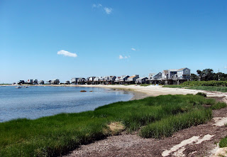
| The homes along the cove adjacent to Pine Island Pond. |
Sometimes I like to seek out beautiful areas off the beaten path. In Mattapoisett I found such a place along the area called Pine Island Pond. The narrow Cove Road acts as a barrier between the pond and the ocean. I could only go so far as the homes along the cove were private but I was able to park along the side of the dirt road and take in some passing sailboats. Behind me, hovering over the pond was a family of osprey. Their calls were the only sounds besides the lapping ocean waves. I would have stayed longer but with several crying osprey circling overhead I thought it might be wise to move on to my next spot.
My final spot to visit was Ned’s Point Lighthouse at Shipyard Park. It was here that I got a sign that my travel writing was a good choice. Unbeknownst to me I had chosen to visit Ned’s Point Light at one of the few times it was open to the public. Being open on Thursdays from 10:00am to noon in July and August did not give me a large window but I did make it in time.
 |
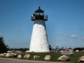
| Ned's Point Lighthouse |
Ned’s Point Light was built in 1838 at the urging of former President, and at that time Massachusetts Congressman, John Quincy Adams . It had been rushed and poorly built at first, needing several rounds of improvements up through 1888. The wooden light keeper’s house was loaded on a barge and floated across Buzzards Bay to Wing’s Neck Light in Bourne in 1923. Russell Eastman, the last keeper at Ned’s Point, rode in the house across the bay on the day. Decommissioned by the Coast Guard in 1952 the light became active again in 1961.
 |
| Mattapoisett Harbor from the top of Ned's Point Light. |
It is a thirty-nine foot stone tower, much different in appearance than the typical lighthouse. I was very excited to get to climb up inside. There were two elderly people, a man and a woman, representing the Coast Guard which owns the lighthouse, there that day. The man was up at the top of the lighthouse, I am not sure how he made it up there. Both of them were very nice and knowledgeable. I was able to see the patches of brown below making an outline of where the keeper’s house had once stood in front of the lighthouse.
From this vantage point I could see clearly from the previously mentioned Pine Island Pond to the southeast down to Mattapoisett  Harbor and the Town Wharf. It was a spectacular sight and I found myself turning my head from side to side over and over like I was at a tennis match. It would have been very easy to stay up on that platform all day but sadly the time to close the lighthouse came and I was forced to relive the experience in my photos afterward.
Mattapoisett has a beautifully relaxed feel to it wherever you visit. A walk along the Town Wharf complete with a visit to the Seaport Ice Cream Slip makes a great start. This can only be topped by checking out Shipyard Park where the unique Ned’s Point Light resides. It does not have to be summer, this quiet little seaside town can be enjoyed 365 days a year. Have fun and happy traveling!
Directions: Ned’s Point Lighthouse: From I-195 West take Exit 19A. Turn right into Mattapoisett. Bear right onto North Street, follow for a mile and a half and turn left onto Water St. which becomes Beacon St. This road becomes Ned’s Point Rd. without any turns. Follow it to the park where the lighthouse is located.
Mattapoisett Town Wharf: From Rt. 6 heading west take a left at Marion Rd. Turn right at Water St., follow it a half mile to the Town Wharf on the left. Seaport Ice Cream Slip is on the far left after you enter.
References: Mattapoisett, Ma. - Official Town Site


