Pages

Thursday, November 18, 2010

In My Footsteps: Trip 85: Thomaston, Maine

In My Footsteps
Christopher Setterlund


Trip 85:  Thomaston, Maine
October 2, 2010


            The tiny old seaport of Thomaston amazed me with its quaint, peaceful feeling.  However it was the ‘Museum in the Streets,’ an absolutely brilliant idea, that made this trip stand out for me.  The ‘Museum’ consists of thirty panels strategically located in front of, or across the street from, important and historical sites in the town.  These panels made the entire town appear to me to be more of a scavenger hunt; it was such a fun experience.  
Replica of Gen. Knox's Montpelier.
            Located in the area around the St. George River, the land on which Thomaston stands was originally a trading post established in 1630.  The most famous name associated with Thomaston is that of General Henry Knox.  Knox was a Revolutionary War hero who played a pivotal role in the ‘Siege of Boston’ in 1775-76 by bringing captured cannons to Boston from Fort Ticonderoga along the shore of Lake Champlain.  He brought them by sled a distance of over 200 miles.
            Knox became a close friend of George Washington when he was a General and Washington made him the United States’ first Secretary of War once he was named the first President.  There are two separate forts named for him, one near Louisville, Kentucky and another located in Prospect, Maine.
The only remaining building from the original Montpelier estate.
Knox retired to Thomaston in 1795 to his estate called Montpelier.  That original mansion was torn down in 1871 after it had decayed and Knox’s oldest grandson had no desire to repair it.  The only building remaining from the original Montpelier estate is a small brick building which was used as the train station for the Knox and Lincoln Railroad.  That building currently houses the Thomaston Historical Society.
The current Montpelier Museum is a reconstruction located on a hill at the corner of Rt. 1 and Rt. 131.  It is a magnificent building at an equally magnificent location.  There is a parking area off to the right of the white building; I parked in front of it where there is a small turnoff.  The building looked to me a lot like the White House with the golden eagle above the front door.  It had that sort of regal air to it the way it stands above everything else around it.
Watts Hall
The only surviving building from the original Montpelier is one of the stops on the ‘Museum in the Streets.’  In actuality this building, despite being an original piece of history, is not as eye-catching as the replica of Montpelier.  If I had not been specifically looking for it I would not have known that the small brick building, built in 1795, had any sort of significance but for the oval sign on the façade which alerts you to the fact that this is more than just a run of the mill train station.
The ‘Museum in the Streets’ plaques are scattered all over the little town of Thomaston but the main cluster of them can be found along Main Street and Knox Street.  One historic site I checked out was Watts Hall on Main Street.  The building was erected and donated to the people of Thomaston by Captain Samuel Watts in 1890.  The interesting part of the story is the fact that in 1915 there was a tremendous fire in the stable located behind the building which caused the entire block to burn to the ground.  The current Watts Hall was rebuilt by Watts’ daughter Mary Jane in memory of her father.  The building is used for town meetings and the large auditorium on the second floor is used by several theater groups.
St. Baptist Episcopal on left, Thomaston Baptist on right.
Another spot on Main Street with an interesting story is the location of two churches.  The Thomaston Baptist Church and the St. John Baptist Episcopal Church have been good neighbors ever since they were first built in 1816.  The two institutions have come to symbolize the love and respect between all religions in the small town.  In fact when the Baptist church’s steeple burned down in the 1990’s the money to rebuild it was raised by all of the other religious groups in town.  This lesson of love and respect between religions was not lost on me during this time in the world.
The ‘Museum in the Streets’ comes to an end along the banks of the St. George River where there are four plaques arranged around a large wooden cross on a green.  The cross was erected in commemoration of Captain George Waymouth’s landing there on June 12, 1605.  One of the plaques I found most intriguing was the one which featured information about an old wooden toll bridge which once spanned the river to the west.  There is a normal paved bridge there now but the story is that north of where that bridge stands was an original Indian trading post established by the Pilgrims of Plymouth Colony in 1623.
Cross commemorating George Waymouth's landing.
Thomaston was also known as the town which built more ocean-going vessels than any other town in the entire country.  That fact surprised me when taking a drive around this little town.  It is amazing how much history, such as the building of all of those ships, happened in such a small place. 
There are a total of thirty plaques making up the ‘Museum in the Streets,’ many of those facing the place described on the plaque.  It is a fun way to learn about the history of a great little town, I never imagined during my trip to Maine that I’d been taking part in a sort of scavenger hunt, it was a lot of fun.  I highly recommend any visitor to the area take in the replica of General Knox’s Montpelier estate, breathe the salty air of the St. George River, and take some time to find all thirty of the plaques of the ‘Museum in the Streets.’  Have fun and happy traveling!


For more In My Footsteps items follow my Twitter Feed, view more photos at the In My Footsteps fan page on Facebook, or visit my homepage at ChristopherSetterlund.com.   Thanks for reading!
Directions:  Montpelier Museum:  Take Rt. 1 into Thomaston, turn onto Rt. 131/High St.  Museum is on the left, parking is on left just beyond it.
            St. George River:  Take Rt. 1 into Thomaston, turn right at Knox Street which is next right after Watts Hall.  Follow it to the end.  There is a parking area which is where the final plaques and wooden cross are located.
            Watts Hall:  Take Rt. 1 into Thomaston.  Watts Hall is 110 Main Street/Rt. 1.  This is where a cluster of Museum plaques are located as well.

            General Knox Museum.org
                Thomaston Historical Society.com
               

Thursday, November 11, 2010

In My Footsteps: Trip 84: Owl's Head, Maine

In My Footsteps
Christopher Setterlund


Trip 84:  Owl’s Head, Maine
October 2, 2010


            Throughout the majority of my trips I have taken I have always felt that there was never enough time to see all that I wanted to see.  Getting a chance to spend six days in Maine I thought would be a perfect way to correct that.  Now, after finishing up my trip to Maine I have found out that even six days was not enough to see what I had wanted to see.  That being said, my time in Maine was among the most fun that I have had in my life. 
The living room at Wataview
I owe a huge debt of thanks to my friend Steve Davis who allowed me to stay at his ‘Wataview’ home on Cottage Avenue in Owl’s Head.  This house has an amazing view of Rockland Harbor and the Breakwater Lighthouse.  What a thrill it was for me to be able to sit out on the enclosed porch after dark and simply enjoy the sight of the lighthouse lantern as it spun rhythmically across the water and into the windows.  It is available for rent up until the beginning of October and the website is included at the end of the article.
Owl’s Head is a small town in the mid-coast region of Maine.  It was first explored in 1605 by Samuel de Champlain and was called Bedabedec Point by the Abenaki tribe of Native Americans.  The name means ‘Cape of the Winds.’  The town got its name from mariners who thought the shape of the rock ridge where Owl’s Head Light currently stands looked like an owl.  Though it has over 400 years of history the town was not incorporated until 1921.
Birch Point Beach State Park
 I found Owl’s Head to be in many ways an absolutely perfect snapshot of what I always had thought Maine would look like to me.  After waking up to a beautiful sunrise over the harbor the first place I ventured out to was Birch Point Beach State Park.  This area is one that would qualify as ‘classic Maine’ with its outcropping of rocks lined with straight-as-towers pine trees stretching out into the cool Atlantic waters.
The road to the beach was closed so I needed to walk to get to the water.  This was a welcomed addition to my trip as it gave me a chance to take in the rapidly changing leaves whose colors were made even brighter by the strong morning sun.  The beach was magnificent as I hit it at low tide and was able to walk out on some of the dry rocks and get a great view of the Mussel Ridge Channel Islands which sit about a mile off shore.  This area ended up being the best possible starting point for my time in Maine and it only got better from here.
Entrance to the Transportation Museum
The next spot I visited was the Owl’s Head Transportation Museum located on Museum Street.  The drive from Birch Point to the museum was so amazing that I almost did not want it to end.  Everything shone from the sun, every home, every tree, it was all too perfect.  The Transportation Museum has an unbelievable collection of items, it is a day trip all in itself.  There are originals and replicas of aircraft dating all the way back to 1804.  The thirteen-inch unmanned glider built by the ‘Father of Aviation,’ Sir George Cayley, is replicated here.  It is amazing to see where aviation began to where it is today.
Owl's Head Harbor
The Museum also has an impressive collection of antique cars as well including a three-wheeled open air vehicle built by Karl Benz in 1885.  It looks incredibly out of place even among vehicles from thirty years later but there are many features to it which are still used in cars today.  I found the vehicles from the 19th and very early 20th century to be the most interesting mostly because of the history and how these awkward looking vehicles actually changed the world.
After leaving the Transportation Museum I headed to Owl’s Head State Park located on the northeast corner of the wide peninsula.  It is here that the spectacular Owl’s Head Lighthouse resides.  This area contains the rocky cliff that gave Owl’s Head its name, although it is impossible to see from where the lighthouse is situated.
Owl's Head Lighthouse
From the parking lot it is a short walk to the lighthouse itself.  The walk contains some more incredible views of the rocky cliffs and a gray sandy beach located near the parking lot.  Once you get to where the Coast Guard Station and Owl’s Head Lighthouse are the cliffs get much higher and the views include all of the surrounding area.
I found it odd yet thrilling that a lighthouse was built in such a spot.  Built in 1852 the lighthouse itself is only thirteen-feet tall yet it can be seen for miles because the light is 100 feet above sea level thanks to the gigantic cliffs.  The stairway which leads up to where the lighthouse sits made for some fantastic photo opportunities, and the view from the top was the perfect capper to my day in Owl’s Head.  The walk and the stairs should not deter anybody from paying this marvelous site a visit.
Although it is a small town population wise, and a new town as far as being officially recognized, Owl’s Head is filled with amazing places to see.  The Owl’s Head Transportation Museum is a day trip itself and is a must see.  I highly recommend paying a visit to Owl’s Head Lighthouse for the incredible views.  For a taste of what I believe is ‘classic Maine’ there is Birch Point Beach State Park.  If you see all of those places then I also recommend simply pointing your vehicle in any direction and taking a slow drive through the streets of this awesome little town.  Have fun and happy traveling!

*For more In My Footsteps items follow my Twitter Feed, view more photos at the In My Footsteps fan page on Facebook, or visit my homepage at ChristopherSetterlund.com.   Thanks for reading!


Directions:  Birch Point Beach State Park:  Take Rt. 1 into Rockland, turn right at Rt. 73, follow it 4 miles, turn left at Dublin Rd., turn right at Ballyhac Rd.  Follow it to signs for park, there is some parking if gate is closed.
            Owl’s Head Transportation Museum:  Take Rt. 1 into Rockland, turn right at Rt. 73, follow it almost 3 miles, turn left at Museum St., there is a sign for the museum at entrance.
            Owl’s Head Lighthouse:  Take Rt. 1 into Rockland, turn right at Rt. 73, follow it almost 2 miles, turn left at N. Shore Drive.  Turn left at Main St. near Post Office, turn left at Lighthouse Rd. follow it to parking lot.  

                Mussel Ridge Historical Society
            Owl's Head Official Town Site

Sunday, November 7, 2010

In My Footsteps: Trip 83: Manchester, New Hampshire

In My Footsteps
Christopher Setterlund


Trip 83:  Manchester, New Hampshire
September 21, 2010


            Consistently ranking as one of the best places to live in the United States I had very high expectations for Manchester even before I arrived.  After leaving I can say that it lives up to every word of its reputation.  It is every bit a city with tall buildings and busy streets yet it never seemed as imposing to me as places like New York and Boston can be at times.
Weston Tower
            My time in Manchester began with a tower and ended with a tower, the Weston Tower and Smyth Towers respectively.  Weston Tower, on Oak Hill Drive, was built in 1896-97 during the 50th anniversary of the city.  It was built in honor of James Adams Weston who was four times mayor of Manchester during the 1860’s and 70’s.  It is a magnificent granite structure standing sixty-six feet tall with the observatory being an astounding 360 feet above sea level thanks to the hill it stands on.  On this day that I visited the road up to the tower was closed and so I had to walk, but it is not far.  When it is open the observation deck is a great place to see some of the great sights of New Hampshire.
            Smyth Tower is located on the grounds on the Manchester VA Medical Center which makes it stand out even more.  This tower, another which looks like Scargo Tower in Dennis, was built in 1888 as a hideaway for then New Hampshire Governor Fredrick Smyth.  I found it an interesting mix with the tower sitting on a small grassy plateau seemingly untouched from when it was originally built; this is in stark contrast to the walls of steel and glass of the hospital no more than fifty feet away.  These towers were the bookends of my time in Manchester but there was so much more to see in one of the best cities to live in.
            For beautiful scenery there is Stark Park on River Road.  The park itself is very wide open and it is easy to navigate thanks to winding gravel roads which make it possible to find your own piece of shade in which to relax.  There were many cars spaced out all over the park with people lying back in their seats.  I took a walk around this park and realized it is much more like a neighborhood than just a park.
Stark Park
            In the center of the lush green grass is a huge statue of the man the park is named for: General John Stark.  Stark was a Revolutionary War hero and was known as the ‘Hero of Bennington’ for his service at the Battle of Bennington in 1777.  Stark was born is what is today known as Derry, New Hampshire and moved at age eight to modern-day Manchester.  His grave, as well as that of three generations of Starks, is located in the back of the park surrounded by an iron fence.  These graves show you that General Stark was a real person and not just some name engraved on a statue.
            The soul of Manchester can be felt while walking Elm Street and taking a stroll out onto the Notre Dame Bridge.  I enjoyed Elm Street because while it was in many ways the typical city street with high rise buildings and hotels it was pretty much the only street that looked that way to me.  Much like I mentioned about Newport, New Hampshire and a few other towns I have seen there were many brick buildings with names located up near the roof level.
            There are some odd things about cities that I find fascinating.  One such thing is when there are old advertisements on the sides of the brick buildings that seemed to just be ignored.  This was the case on the Dunlap Building and I have seen it before in Taunton where there was an awesome old Coca-Cola ad on the side of a building.
View from the Notre Dame Bridge
            The Notre Dame Bridge which spans over the Merrimack River as it runs through Manchester gives an amazing view of the city with the water and foliage providing a perfect backdrop.  While this walk might not be for everyone I thoroughly enjoyed getting to see this side of Manchester.  The spots that caught my eye the most were the Jefferson Mill to the north with its green peaked roof, clock tower, and ‘Jefferson’ in cursive on the façade.  Also catching my attention to the south was the building at 900 Elm Street which stood out not only because it was one of the tallest buildings but it had two different colored walls, a deep red and a clear color, plus a green roof similar to the Jefferson Mill.
Entrance to the Red Arrow Diner.
            I will admit that as great as my trip to Manchester was I had been saving the best for last.  The Red Arrow Diner is known nationwide for its amazing food as well as the line of celebrities that have filled its walls.  First opened in 1922 the current incarnation of the Diner is owned by Carol Sheehan who took it over in 1987.  It was voted one of the ten best diners in the country and the list of celebrities that have eaten here include Adam Sandler, Paul Newman, Al Gore, and Guy Fieri.  The seats where famous people have eaten are marked by small red plaques which make each visit special in its own right.  
            Their chili is award winning and I tend to agree with the consensus after having some myself.  The walls are filled with unique memorabilia and photos.  It is the consummate diner experience down to the last detail.  It is obvious why people make it a regular stop in their lives.  There is a lot of Red Arrow merchandise as well which means even if you live far away such as I do you can always have that smiling coffee mug logo wherever you are.
            Manchester is consistently rated as one of the best cities to live in the United States and after visiting it is easy to see why.  With beautiful stone towers, lush green parks, beautiful river scenery, a bustling but not overpowering city life, and of course an amazing diner, Manchester is easily a place where I can see myself going back to again and again.  Have fun and happy traveling!

     My first book, In My Footsteps: A Cape Cod Travel Guide, is now available at SchifferBooks.com, BarnesandNoble.com, and Amazon.com, soon to be in stores everywhere!  Follow me on Twitter!

Directions:  Stark Park:  From I-93 north take Exit 9S for Rt. 28, after 1.7 miles turn right at Webster St.  Turn right at Elm St., take 2nd left onto Monroe St., turn right at River Rd.  Follow it .5 miles to entrance on left.
            Red Arrow Diner:  From I-93 north take Exit 8 onto Wellington Rd., continue onto Bridge St., follow it 1.4 miles, turn left at Kosiuszko St.  Turn left at Lowell St.  Parking is on either side of road.
            Weston Tower:  From I-93 headed north take Exit 8 onto Wellington Rd.  Take first right onto Rt. 28A, turn left at Stockholm St., turn right at Oak Hill Drive.  Tower Hill Rd. is on left, if gate is closed it is a short walk to tower.

References:  Red Arrow Diner
             Friends of Stark Park
            Manchester, NH.gov

Thursday, November 4, 2010

In My Footsteps: Trip 82: Concord, New Hampshire

In My Footsteps
Christopher Setterlund


Trip 82:  Concord, New Hampshire
September 21, 2010


            Although it is one of the smallest capitals people-wise in the United States, Concord has an amazing amount of history.  A beautiful city at the end of a beautiful drive down from Central New Hampshire, Concord gives you a chance to be in a city, a state capital none the less, but also retain the feel of a family friendly town.
            It was originally inhabited by the Abenaki tribe of Native Americans and later became known as Rumford upon being settled by colonists between 1725 and 1727.  The name Concord came about in 1765 after a border dispute between Rumford and its neighboring Bow.  The name Concord means harmony and thus the name was meant to reflect the new harmony, or concord between the two towns.
New Hampshire State House
So much of the modern history of Concord has to do with the United States government.  It is easy to get lost in the wonder of the history of Concord as soon as you step foot in front of the State House on North Main Street.  With its golden dome and well kept green lawn heading toward its granite steps the New Hampshire State House is as beautiful as it is historical. 
The State House is the oldest state capitol in the country where the legislators still meet in the original chambers.  The first sessions of the General Court took place here in 1819.  After parking on North Main Street I entered the grounds of the State House through a magnificent granite archway that made me truly feel as though as I passing from the present to the past.  It was an awe-inspiring time to get to stand so close to a spot with such a significant meaning to it.  It has always been known as the ‘people’s house’ and therefore there are no gates around the ground, which also means there is no excuse not to take some time to pay the State House a visit.
Concord also offered me my first opportunity to visit the resting place of a former United States President.  Born in 1804 in Hillsborough, New Hampshire, a small town thirty-six miles south of Concord, Franklin Pierce is as of today the only President born in New Hampshire.  Pierce was the 14th President of the United States, serving from 1853 to 1857.  He also fought as a brigadier general in the Mexican-American War from 1846 to 1848.  He was seen as very personable and therefore made a great deal of friends, however his record as president was less than stellar and is widely forgotten.
The grave of Franklin Pierce.
I first paid a visit to Pierce’s final resting place at the Old North Cemetery on North State Street.  The grave itself is in a small enclosure surrounded by an iron fence.  I was honored to be standing before the grave of a former U.S. President, no matter what his political achievements may have been.  However, I was also amazed at what little fanfare there was to this simple plot.  If I had not gone there specifically to look for Franklin Pierce’s grave I might have passed right by it.  The unspectacular headstone seemed to be fitting of what I have read about Pierce’s life and accomplishments.
The connection to Franklin Pierce continued at the Pierce Manse on Horseshoe Pond Lane.  The term ‘manse’ means ‘a house lived it by its owner,’ it was bestowed upon the house in 1969 as a nod to Pierce’s longtime friend, author Nathaniel Hawthorne.  Hawthorne’s Salem, Massachusetts home was known as ‘The Old Manse.’
The Franklin Pierce Manse
Much like his grave the only place in New Hampshire ever lived in by Franklin Pierce and his family is very unassuming.  I had expected a gigantic mansion but the Manse is much more modest for a President.  Sticking with that theme the Manse was actually saved from being demolished in 1971 by a group called the ‘Pierce Brigade.’  Imagine that?  A home lived in by a former President actually was going to be demolished?  I guess as someone who loves and respects history I find that almost unimaginable.  The home was moved from its original location on Montgomery Street to its current location in 1971 once the land it sits on was acquired.  It is open by appointment year round.         
After leaving the life of Franklin Pierce behind I found a beautiful park which held another smaller, probably less significant piece of history.  White Park, located on White Street is a great place for families to gather for picnics and other outdoor activities but it is the pristine baseball field with unbelievable brick dugouts that caught my eye.
Site of the Sunset Beaseball League at White Park.
I did not know it beforehand but the baseball field, now known as Red Eastman Field, was much more than meets the eye.  It turns out that this field was and still is the home of the Sunset League.  The Sunset League is the country’s oldest evening amateur baseball league formed in 1909.  The original teams’ names were the White Parks, Old Timers, Haymakers, and Sluggers.  This field was a training ground for some future Major Leaguers including Red Rolfe who collected nearly 1,400 hits during ten seasons with the New York Yankees from 1931-42.  After finding this information out I had to stop and really take in the beauty of the field, imagining what it was like when the ‘after supper’ games first began over a hundred years ago.
Finally on my trip to Concord I stopped at the Christa McAuliffe Planetarium.  This was a spot I really wanted to see because of the connection the Space Shuttle Challenger explosion has to my childhood.  I remembered learning about the citizen astronauts, especially Mrs. McAuliffe who was a teacher, when I was in second grade in 1986.  We watched the launch live and saw the unbelievable tragedy as it unfolded.
McAuliffe-Shepard Discovery Center
Seeing this beautiful dedication to Mrs. McAuliffe and to a lesser extent the Challenger crew was a sort of cathartic experience for me.  I really liked the model Mercury-Redstone rocket ship just outside of the building; it stands ninety-two feet tall and was like something out of the 1960’s.  Even if you are not familiar with the Challenger events this planetarium is a must see for science and space lovers.  I really think that if you are not a fan of either you will be by the time you leave.   
Concord, New Hampshire is a state capitol with a small town feel.  It is every bit as historic and filled with everything a city has to offer but it is much less imposing than larger capital cities might be.  Take the time to tour the State House, even just the grounds.  Visit the grave and home of a former president, check out a beautiful historic baseball field, and definitely pay homage to Astronaut Christa McAuliffe at the planetarium named in her honor.  Have fun and happy traveling!

My first book, In My Footsteps: A Cape Cod Travel Guide, is now available at SchifferBooks.com, BarnesandNoble.com, and Amazon.com, soon to be in stores everywhere!  Follow me on Twitter!


Directions:  New Hampshire State House:  From I-93 headed north take Exit 15W for Rt. 202.  Merge onto Rt. 202, turn left after a half mile to stay on Rt. 202, State House is half mile away on right.
            Franklin Pierce Manse:  From I-93 headed north take Exit 15W for Rt. 202.  Turn right at N. Main St., Pierce Manse will be straight ahead at end of the road.
            Christa McAuliffe Planetarium:  From I-93 headed north take Exit 15E for I-393.  Take Exit 1, turn left at Ft. Eddy Rd.  Continue onto College Dr., turn right at Institute Drive.

References:  Pierce Manse.org
                McAuliffe-Shepard Discovery Center
            Concord, NH - Official Site
            New Hampshire Historical Society

Wednesday, October 27, 2010

In My Footsteps: Trip 81: Newport, New Hampshire

In My Footsteps
Christopher Setterlund


Trip 81:  Newport, New Hampshire
September 21, 2010


            Very few things I have seen on my travels so far have been as impressive and breathtaking as my drive through Central New Hampshire.  The mountains are all around you and when it is combined with the oncoming fall foliage it makes for a dreamlike experience.
The Pier Bridge
The amazing view inside the Pier Bridge.
            Newport, New Hampshire, located just west of Mt. Sunapee, is the very definition of a mountain town.  The drive to get there, going through the very well known Sunapee area of New Hampshire, is worthy of an article all its own.  I found it very interesting that despite it being for a totally different reason Newport, New Hampshire was just as beautiful as Newport, Rhode Island.  Where Newport, Rhode Island is beautiful thanks to its mansions and scenic coastline Newport, New Hampshire is beautiful thanks to its covered bridges and scenic mountains.
            First settled in 1763 after a delay due to the hostilities of the French and Indian War, Newport became a very prosperous town thanks to its soil and the Sugar River.  A grist mill and cotton mill were established not too long after but it is a project which never got off the ground that I find most interesting.
South Congregational Church
            In 1817, inspired by the development of the Erie Canal in New York, businessmen suggested that a canal be created between the Connecticut and Merrimack Rivers.  This would have begun at the Sugar River in Newport and would have used Lake Sunapee as a reservoir.  For whatever reason, probably money, this proposed canal project was dropped before the first shovel was plunged into the dirt.  Ironically the Newport-based Sibley Scythe Company, established in 1842, supplied the scythes that were used to clear the jungle away from the site of the Panama Canal when construction began in 1903.    
            The first thing I wanted to see when I arrived in Newport was one of the three covered bridges located within its boundaries.  Even with a GPS these magnificent old relics of a forgotten time were very hard to find.  Luckily two of the bridges were located on the same road, Chandler’s Mill Road.      
            Located a mile down Chandler’s Mill Road is Pier Bridge.  The 216-foot long wooden truss bridge was built in 1907 and crosses over the Sugar River.  It was built to replace a wooden lattice bridge from 1871 which was used by the Sugar River Railroad.  The tracks are no longer there but there is a nice, wide dirt path which will lead to the second bridge, Wright Bridge, less than a mile walk away.
Newport's Town Hall & Court House
            For the Pier Bridge there is a small dirt area where I parked, it is an easy walk to the entrance of the bridge.  I have only seen one other covered bridge and that was in Vermont so standing inside this wooden masterpiece with only the sound of the birds and the soft trickling of the water below was something wonderful.  I truly felt like I was alone in the world during the time I was underneath the shelter of Pier Bridge.  The sunlight trickled in from all sides through the small spaces between boards.  It was something that words won’t do justice to, a photo will do much better.
            I did not choose to walk the .8 miles to the Wright Bridge.  Looking back I should have as my treasure hunt using my GPS led me way off track, I ended up at a point where there were no markings on the GPS screen, only white.  Needless to say after a few drives up and down Chandler’s Mill Road I gave up and headed to my next destination.  Still, I was so happy to get to stand underneath one of only eight covered railroad bridges in the entire country.
            The next stop during my time in Newport consisted of a walk down Main Street.  I parked at the historic South Congregational Church, built in 1823, which stands stoically over the surrounding homes and businesses.  The warm autumn day combined with the colorful leaves made this walk a pleasure, however, the places I got to see on Main Street were in a class of their own.
            There is a saying that the ‘whole is greater than the sum of its parts,’ that is sort of the case with Newport’s Main Street.  Yes there are many historic buildings but the entire scene as I walked along through the peaceful mountain town was something I wanted to capture and take with me when I had to leave.
            There is the beautifully sculpted Golden Eagle, a replica of the eagle crafted by Stephen Hasham of Charlestown, New Hampshire which once sat atop the Eagle Hotel.  It will definitely catch your eye as you pass by as it did for a small group of elementary school students who were out on a field trip on this day.  Sometimes that is how I feel as well.
The awe-inspiring Train Mural on Main Street.
            A few steps away is the mammoth brick Newport Town Hall & Court House built in 1886.  In fact there are several brick buildings, all from around the same time period, 1880’s and 1890’s which stand along Main Street.  The really neat thing about them, and this is the case in other towns I have visited, is that they each have names, usually on a smoky gray background.  I saw the Lewis Block, DeWolf, and Wheeler’s Block as I walked.  I can only assume they were named for those who put up the money to have them built.
            One amazing sight, off the beaten path, along the side of the Johnson Block building is ‘The Train Mural.’  It is an awe-inspiring hand painted depiction of the four seasons of New Hampshire along with some well known sites from the town of Newport.  This is a perfect way to get a taste of what this town is really all about if you do not have the time to walk.  I have been unable to find any information as to how old the Train Mural is, or who painted it, but they deserve great thanks for creating something so beautiful.
             Newport, New Hampshire is every bit as beautiful as its counterpart in Rhode Island.  From the covered railroad bridges to the trip to a simpler time that my walk on Main Street provided it is a town that I will not soon forget.  I hope everyone gets the chance at some point to visit this classic mountain town and to take in all of its beauty; it is worth any length of time to get here.  Have fun and happy traveling!  

     My first book, In My Footsteps: A Cape Cod Travel Guide, is now available at SchifferBooks.com, BarnesandNoble.com, and Amazon.com, soon to be in stores everywhere!  Follow me on Twitter!

Directions:  Pier Bridge:  From I-89 headed north take Exit 12 for Rt. 11.  Turn left at Rt. 11, follow it 11 miles, turn left at N. Main Street.  Take 3rd right onto Rt. 103, follow 3 miles, turn left at Chandler’s Mill Rd., bridge is 1 mile up on right.
            Main Street:  From I-89 headed north take Exit 12 for Rt. 11.  Turn left at Rt. 11, follow it 11 miles, turn left at N. Main Street, there is parking on the right side of street.   

References:  Newport, NH.net
            Newport, NH History.org
           

Saturday, October 23, 2010

In My Footsteps: Trip 80: New London, New Hampshire

In My Footsteps
Christopher Setterlund


Trip 80:  New London, New Hampshire
September 21, 2010


            As my travel trips grew further and further from home I knew it was time to do my first overnight trip.  I found a perfect place to begin and a perfect place to stay as well.  New London, New Hampshire, a nearly three and a half hour drive for me from my home on Cape Cod was the setting for my first overnight stay ad it was amazing.  The drive up through the eastern fringe of the White Mountains as the sun began to set was something that I will never forget for the rest of my life.
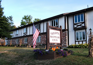
The Lamplighter Motor Inn
            I chose to stay at the Lamplighter Inn on Main Street as it was recommended to me by a friend.  It ended up being the perfect place to stay.  Located just off of the main drag in New London the newly renovated Lamplighter is owned by Mr. Ernest Collier who took over the motel in March.  He has made some marked improvements which have made this spot a great landing place for any visitor to the area.  I thoroughly enjoyed my stay at the Lamplighter Inn and recommend it to anyone who travels to the New London area.
            To get a feel for what this small, near-mountain, town is all about I suggest taking a stroll along Main Street.  The small Colby-Sawyer College sits not far from where I stayed and there was a sprinkling of students along the street, though not as overwhelming as some college towns can be.  A sort of fun scavenger hunt for walkers on Main Street is to find all of the elaborately painted bull statues that reside along the sidewalks on either side.  They are beautiful although I cannot say for sure whether they are the result of the students at Colby-Sawyer for sure.
Looking across Sargent Common toward the Town Hall.
            I was lucky enough to plan my trip just as the foliage in central New Hampshire was getting into full gear.  The red, orange, and yellow leaves seemed to be springing up as I watched.  This added bonus made each and every photo I took even better.
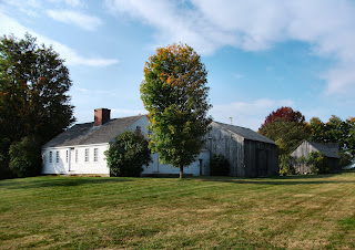
            The very famous New London Inn stands out as an historic landmark on Main Street.  The land was first built upon in 1792 when 19-year-old Ezekiel Sargent built a farmhouse where the current Inn stands.  The Sargent family is intertwined with the history of the Inn as well as the town of New London.  In fact a short walk away from the New London Inn is a beautiful green area known as The Sargent Common.  Much of the original tract of land owned by Ezekiel Sargent ended up being part of the ‘Old Campus’ of Colby-Sawyer College though only the ‘Old Academy’ building still stands today.
Schytheville House at the Historical Society
According to the New London Inn’s website 1870 was when the farmhouse first became used as a hotel by a man named Herman J. Currier.  He bought the farmhouse and named it The Elms.  It is a very popular destination not only for overnight travelers looking for a room but for anybody who is a fan of history such as I am. 
               For a real taste of New London’s history though one only has to travel on Little Sunapee Road to the Historical Society.  It is more than one building, more like a small village of fourteen original or replica buildings.  The Scytheville House, built in 1835, is the face of the Historical Society as it is the first home you will see as you approach.  I was amazed at the peaceful tranquility of the location.  There was barely a peep from anything as I walked the grounds.  All around were the sights of the nearby White Mountains which were a constant reminder of just how far from home I was.  To make this scene complete were a pair of apple trees in full bloom by the road.  I enjoyed their shade for a moment before continuing on my way.
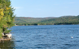
A view of Pleasant Lake.
            Further up the road is New London’s main public beach known as Bucklin Beach.  It is on the shores of Little Lake Sunapee.  Though it was a bit too cool to swim I still enjoyed the tremendous scenery that seemingly exists everywhere in New London.  This beach became a popular tourist destination in the late 19th Century and many of those vacationers eventually built summer homes along its shore.  There was even a small golf course built in the area way back then but it no longer exists.  I was also intrigued by a home built on a concrete breakwater sticking out close to a hundred feet into the water.  Not knowing if it was inhabited or not I enjoyed it from afar and went about my business.   
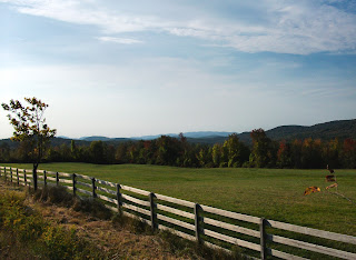
            What I took from my trip to New London though on top of everything was the incredible scenery.  There are so many places to stop and gaze off at the endless green hills which were dotted red and orange.  There are no bad spots to stop but I will give a couple of places that I thoroughly enjoyed. 
Some of the amazing New London scenery.
            Pleasant Lake was the first place I visited early in the morning and it gave me an entirely different perspective seeing the array of colors in the early morning sunlight.  There are several places to stop and look along Bunker Road.  There is also a sign which tells the story of the very first inhabitants of the area with artifacts that have been found in the area which date back thousands of years.  It is very easy to see why such a spot would be a popular settlement area.
            Another place with an amazing view is actually on Main Street, not really a designated area like Pleasant Lake.  I parked across the street from the historic Moses Trussell House, built in 1808, to take a few shots of the beautiful home on the hill.  On the other side of the street is an old barn which is now an antique shop.  There is a large tract of fenced in land which stretches out before you and then gives way to the rolling hills and mountains of Central New Hampshire.  My words will only do so much to describe it; you need to see it for yourself.
            My first overnight trip was a huge success thanks first to the great room at the Lamplighter Motor Inn and secondly because of the never-ending stream of awe-inspiring views.  A walk on Main Street will give you a feel of what this small college town is all about, and a drive to the Historical Society or along any of the smaller back roads will make sure that New London, New Hampshire seeps its way into your soul.  Have fun and happy traveling!   

Directions:  Lamplighter Motor Inn:  From I-89 heading north take Exit 11 for King Hill Rd, turn right.  Turn left at Rt. 114.  Follow it just over 2 miles, turn left at fork in road for Newport Rd.  Lamplighter Inn is on right #34. 
            Pleasant Lake:  From I-89 heading north take Exit 11 for King Hill Rd, turn right.  Turn left at Rt. 114.  Turn right at Pleasant St., turn right at Bunker Rd.  Lake is on the left.
            Historical Society Village:  From I-89 heading north take Exit 11 for King Hill Rd, turn right.  Turn left at Rt. 114.  Follow it just over 2 miles, at fork stay right, becomes Little Sunapee Rd.  Historical Society is .3 miles up on left.  

References:  Lamplighter Motor Inn
            New London Inn
            New London Historical Society.org