Pages

Showing posts with label scusset. Show all posts

Saturday, April 6, 2024

Initial Impressions 2.0 #10: Photo Trip Day

#10: Photo Trip Day


1. For the first time since restarting this blog I actually took my camera and hopped into my car for a fun day of travel and photography. The plan was to get off of Cape Cod and head up the South Shore of Massachusetts. My best guess was that I drove a total of about 130 miles, not as crazy as my old travel writing trips, which tended to be 200+ miles, but still good nonetheless.


2. I actually began the trip by getting gas at a new Seasons/Shell store near where I live. The funny thing is that now with this gas station where it is, there are 4 gas stations on the same road within about 1/3 of a mile. That would seem a bit much even for a larger town/city but is major overkill for the relatively small town where I live. 

UPDATE: 1 of them has already closed in the time that I first wrote this so ONLY 3 gas stations within 1/3 of a mile.


3. Scusset Beach State Reservation is at the entrance to the Cape Cod Canal on the mainland side. It’s one part popular and one part out of the way. There’s camping, some hiking, and naturally a large swath of beach. It even is the starting point of the canal’s bike path so it comes highly recommended.


Scusset Beach


4. If you’re driving along the Massachusetts South Shore and aren’t in a hurry to get anywhere I would suggest taking Route 3A. It hugs the coast and keeps you close to many beautiful areas and attractions. I am always a fan of scenic routes anyway. I will admit though that there are parts of this road where there is absolutely nothing and I find myself tempted to jump on the highway for a bit.


5. I took the scenic route from Sagamore Beach north about 35 miles to Marshfield. I had one place in mind to shoot. It is what I can only describe as an abandoned lobster shack, only a bit larger, on this small rocky island in the middle of the North River. It’s near what’s called Damon’s Point and lies along what used to be a railroad thruway. Of course a picture’s worth 1,000 words.

The shack at Damon's Point in Marshfield


6. I often say I am more lucky than good when it comes to photography. This was proven again when as soon as I arrived at Damon’s Point a bald eagle from a nearby nest began to fly overhead. The photos are nothing earth-shattering, but still getting photos of bald eagles are tough regardless. I have gone to areas near me that are home to eagle’s nests and have never seen one, but totally by coincidence here I find them when looking for something else.


7. There is this really cool metal-sculpted dragon along Route 3A in Duxbury, Massachusetts. Apparently, the family that created it named it Draco. I have passed it a few dozen times and nearly every time I tell myself this is the time I will stop and take photos. Of course that has yet to happen. I’ll have to settle for this profile video from WCVB for now. https://www.wcvb.com/article/chronicleroute-3a-hes-duxburys-home-grown-dragon/8103426


8. I will always have a soft spot in my heart for the town of Plymouth. I feel a deep connection there anytime I visit. Maybe it’s my love of the history but it feels like a second home to me. I typically enjoy visiting the National Monument to the Forefathers. This is lesser known and resides in what is basically a residential neighborhood. The granite monument stands 81 feet tall and is topped by the depiction of Faith pointing toward the sky. If you’ve never seen it check it out for sure.


National Monument to the Forefathers


9. I made this photo trip a dedication to the 1980s. This means you get outside and don’t come home until the streetlights come on. I took my time driving from Marshfield back toward Cape Cod. Luckily the sunset was worth stopping for next to the Sagamore Bridge along the canal. I feel happy with a sense of accomplishment after these types of long photo trip days. I just wish I could turn these passions into something more.


Sunset at the Sagamore Bridge


10. Photo trips like this have become increasingly rare, especially after COVID-19. I feel like I almost got used to being stuck in one small area for so long. I don’t know if anyone else can relate. I hope that over the upcoming months, I will regain that drive to do more trips since I love travel, photography, and then sharing what I’ve seen with as many people as possible.


Subscribe to the YouTube Channel


Saturday, July 23, 2022

In Their Footsteps: Cape Cod History - The First Cape Cod Canals


In 1914 the Cape Cod Canal opened and changed maritime travel in New England and beyond forever. The man-made waterway that connected Buzzards Bay to Cape Cod Bay had its construction begun June 1909. It was created by joining the Scusset River and the Manomet River. For over a century the Cape Cod Canal has been a well-traveled waterway. However did you know that the Cape Cod Canal was not the first attempt at created a cut-through around the Cape? What follows is the story of two other canal attempts in the decades before the current Cape Cod Canal was constructed.

The first attempted man-made cut through Cape Cod came two centuries ago much further east than the current canal location. ‘Jeremiah’s Gutter’ was the name of this waterway. ‘Gutter’ is another word for a channel or waterway. The name ‘Jeremiah’ comes from Jeremiah Smith who came from a founding Eastham family of the late 17th century.

On April 26, 1717 a strong nor’easter battered Cape Cod. It was in this storm that the famed pirate ship Whydah sank with all of its treasure aboard. This storm also carved a channel of varying depths running roughly from Town Cove in Orleans west to what is today Boat Meadow Beach in Eastham. The channel was used by British vessels trying to recover the sunken Whydah treasure in 1717. Afterwards it began to close up due both to nature and locals filling it in manually. The marshlands surrounding the channel, which stretched across the Cape from bayside in Eastham to oceanside in Orleans, often flooded causing the channel to be resurrected in a shallow form over the next several decades.

In 1804 it was decided to widen and deepen the passageway out along the previously created channel which ran over a mile and a half, nearly congruent with the Eastham/Orleans town line. The canal was named Jeremiah’s Gutter to honor Jeremiah Smith as it was much of his property that the waterway ran across.

Despite Jeremiah’s Gutter being widened and deepened it was barely used for nearly a decade. This changed during the War of 1812. It was during the second war with the British that the canal was used as a passageway by American ships carrying salt to avoid England’s blockade of Provincetown. This was the Gutter’s largest claim to fame.

c. Google Maps


Due to the large system of sandy tidal flats along Cape Cod Bay stretching from Brewster to Eastham the bay-side entrance to the canal often became choked with silt making that entrance way unreliable at low tide. It again was sparsely used by traveling vessels and would not be maintained. Jeremiah’s Gutter fell into disrepair and ceased to be used as a passageway for boats, although as late as 1844 large enough storms and tides would push water through making the canal whole again for a brief time.

Though it had begun fading into history the canal would have one more brush with fame when author Henry David Thoreau would mention Jeremiah’s Gutter in his iconic 1865 book Cape Cod. After that the eyes of the Cape would begin searching for a different location to create a more dependable canal. The idea of a new canal became more pressing during the late 1880’s when shipwrecks along Cape Cod’s coast occurred once every two weeks.

This is where the second canal comes into play. Jeremiah’s Gutter was a somewhat functioning canal. The new canal idea migrated west to Bass River. This was another natural waterway stretching from Nantucket Sound, up Bass River, and into Follins Pond.

Though ideas for another canal on Cape Cod had been bandied about for decades the proposed Bass River Canal first came to light in early 1887. It was the brainchild of longtime local shipping merchant Thomas Bacon. He had several good reasons why a man-made waterway would work at Bass River. First off it would save lives as the rough waves and shoals along the Atlantic Ocean side of Cape Cod had proven to be extremely dangerous for ships for centuries. In addition to being roughly ¾ finished already thanks to nature Bacon determined there would only be roughly two miles of excavation necessary between Follins Pond and Cape Cod Bay.

The original Bass River Bridge in the mid-1800's.(Historical Society of Old Yarmouth)


The natural waters were an average of ten-feet in depth. Bacon desired that the proposed canal be closer to sixteen-feet on average. The assumption was that the canal would empty into Cape Cod Bay through the flats between Bass Hole and Chapin Beach. Bass River was about 175-feet wide at its narrowest with its gravelly shores leaving little work to be done. Bacon’s plan was received well by those in the shipping industry. He enlisted the help of the newfound Cape Cod Ship Canal Co. to work with him on getting the project financed and underway.

Early estimates by Bacon had approximately two years of work needed to fully construct the Bass River Canal. He told a Boston Herald reporter in March 1887 that such a project would cost somewhere around $2.5 million($78 million in 2022). Throughout the spring of 1887 support grew for the canal with opposition being surprisingly low. Things progressed so well in fact that by November 1887 engineer Charles Thompson was surveying the proposed canal route.

Shockingly despite there seeming to be little reason why not to construct the Bass River Canal it was unanimously voted down by the committee on harbors and public lands in April 1888. Bacon was undeterred and the project was once against submitted to State Legislature in October 1888. His petition was ultimately withdrawn in January 1889.

It appeared as though the growing interest in building a canal between Bourne and Sandwich was making Bacon’s Bass River location less appealing. In addition Thomas Bacon had grown impatient with the efforts, or lack thereof, of the Cape Cod Ship Canal Co. to get the Bass River Canal project moving. In December 1890 Bacon petitioned to have the company removed from the project so that he could move on and find a more suitable finance partner. He then created the Bass River Canal Co.

In the court of public opinion it was a battle between the Bass River route and the Bourne-Sandwich route. The locals wanted a canal and were less interested in the bureaucratic battles behind the scenes between Bacon and the Cape Cod Ship Canal Co.

Thomas Bacon and his backers continued to petition the committee of harbors and public lands in 1891. There were conditions on the route’s width and depth, with provisions that a certain amount of capital($1 million) needing to be raised first before construction could begin. Several meetings were held with locals giving their two cents of the pros and cons of the canal.

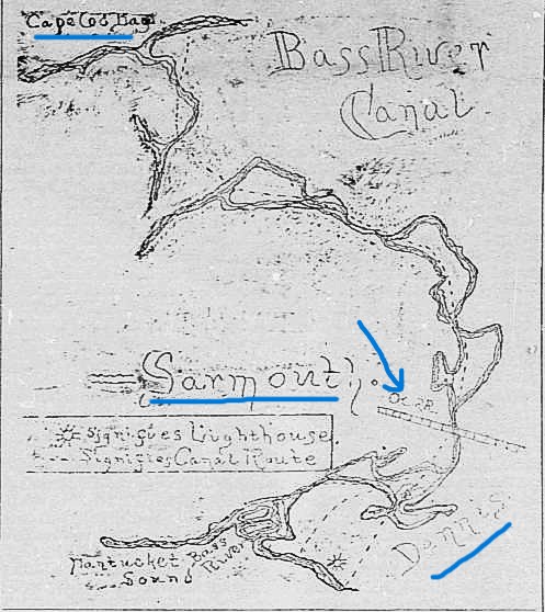
As momentum grew for a canal connecting Buzzards Bay to Cape Cod Bay Thomas Bacon’s Bass River project was continuously pushed down the road. Meetings and petitions were delayed and postponed repeatedly. In December 1891 things seemed to gain traction when civil engineer A.H. Knowles completed a thorough survey of the proposed route including a hand-drawn map.

The 1891 Bass River Canal map. The arrow points to where the Bass River Bridge was.


The Bourne-Sandwich canal was still seen as less feasible which gave the Bass River Canal hope in 1893 when it was yet again submitted as a petition. In June 1894 the Massachusetts House voted in favor of the Bass River Canal, and a year later the company secured a charter. Plans were in place to begin construction which was estimated to last two years and cost between $5-8 million ($176-282 million).

Sadly this is where the project died a death. After four years the charter had been dissolved and no work was ever done on the proposed Bass River Canal. In 1899 the charter for building a canal was granted to the Boston, New York, and Cape Cod Co. which intended to build the canal between Bourne and Sandwich.

For several years after the Bass River Canal Co. attempted to regain their own charter for their canal. Finally in May 1904 the Massachusetts State Senate dealt the company its death blow by flat out rejecting the Bass River Canal proposal. The doorway was open and in 1904 August Belmont purchased and reorganized the Boston, New York, and Cape Cod Co.

Sunset at the Cape Cod Canal.


The rest is history. Work began on the Cape Cod Canal as we know it on June 19, 1909, opening on July 29, 1914. The Bass River Canal idea, much like Jeremiah’s Gutter before it, faded into history. Or did it?

In 1966 rumblings began of a potential look into the feasibility of a Bass River canal. There was even a proposal in February 1966 for $15,000 for a study into whether such a project could be done. However, nothing came from it.

In the end Jeremiah’s Gutter actually was used by boats. The Bass River Canal spent decades locked in legislation before being dissolved without even a spoonful of dirt being shoveled. It is interesting though to think of what Cape Cod would look like today with a Bass River Canal and the Scusset and Manomet Rivers still intact in Bourne and Sandwich.
-------------------------------------------------------------------------