Pages

Showing posts with label buzzards bay. Show all posts

Saturday, July 23, 2022

In Their Footsteps: Cape Cod History - The First Cape Cod Canals


In 1914 the Cape Cod Canal opened and changed maritime travel in New England and beyond forever. The man-made waterway that connected Buzzards Bay to Cape Cod Bay had its construction begun June 1909. It was created by joining the Scusset River and the Manomet River. For over a century the Cape Cod Canal has been a well-traveled waterway. However did you know that the Cape Cod Canal was not the first attempt at created a cut-through around the Cape? What follows is the story of two other canal attempts in the decades before the current Cape Cod Canal was constructed.

The first attempted man-made cut through Cape Cod came two centuries ago much further east than the current canal location. ‘Jeremiah’s Gutter’ was the name of this waterway. ‘Gutter’ is another word for a channel or waterway. The name ‘Jeremiah’ comes from Jeremiah Smith who came from a founding Eastham family of the late 17th century.

On April 26, 1717 a strong nor’easter battered Cape Cod. It was in this storm that the famed pirate ship Whydah sank with all of its treasure aboard. This storm also carved a channel of varying depths running roughly from Town Cove in Orleans west to what is today Boat Meadow Beach in Eastham. The channel was used by British vessels trying to recover the sunken Whydah treasure in 1717. Afterwards it began to close up due both to nature and locals filling it in manually. The marshlands surrounding the channel, which stretched across the Cape from bayside in Eastham to oceanside in Orleans, often flooded causing the channel to be resurrected in a shallow form over the next several decades.

In 1804 it was decided to widen and deepen the passageway out along the previously created channel which ran over a mile and a half, nearly congruent with the Eastham/Orleans town line. The canal was named Jeremiah’s Gutter to honor Jeremiah Smith as it was much of his property that the waterway ran across.

Despite Jeremiah’s Gutter being widened and deepened it was barely used for nearly a decade. This changed during the War of 1812. It was during the second war with the British that the canal was used as a passageway by American ships carrying salt to avoid England’s blockade of Provincetown. This was the Gutter’s largest claim to fame.

c. Google Maps


Due to the large system of sandy tidal flats along Cape Cod Bay stretching from Brewster to Eastham the bay-side entrance to the canal often became choked with silt making that entrance way unreliable at low tide. It again was sparsely used by traveling vessels and would not be maintained. Jeremiah’s Gutter fell into disrepair and ceased to be used as a passageway for boats, although as late as 1844 large enough storms and tides would push water through making the canal whole again for a brief time.

Though it had begun fading into history the canal would have one more brush with fame when author Henry David Thoreau would mention Jeremiah’s Gutter in his iconic 1865 book Cape Cod. After that the eyes of the Cape would begin searching for a different location to create a more dependable canal. The idea of a new canal became more pressing during the late 1880’s when shipwrecks along Cape Cod’s coast occurred once every two weeks.

This is where the second canal comes into play. Jeremiah’s Gutter was a somewhat functioning canal. The new canal idea migrated west to Bass River. This was another natural waterway stretching from Nantucket Sound, up Bass River, and into Follins Pond.

Though ideas for another canal on Cape Cod had been bandied about for decades the proposed Bass River Canal first came to light in early 1887. It was the brainchild of longtime local shipping merchant Thomas Bacon. He had several good reasons why a man-made waterway would work at Bass River. First off it would save lives as the rough waves and shoals along the Atlantic Ocean side of Cape Cod had proven to be extremely dangerous for ships for centuries. In addition to being roughly ¾ finished already thanks to nature Bacon determined there would only be roughly two miles of excavation necessary between Follins Pond and Cape Cod Bay.

The original Bass River Bridge in the mid-1800's.(Historical Society of Old Yarmouth)


The natural waters were an average of ten-feet in depth. Bacon desired that the proposed canal be closer to sixteen-feet on average. The assumption was that the canal would empty into Cape Cod Bay through the flats between Bass Hole and Chapin Beach. Bass River was about 175-feet wide at its narrowest with its gravelly shores leaving little work to be done. Bacon’s plan was received well by those in the shipping industry. He enlisted the help of the newfound Cape Cod Ship Canal Co. to work with him on getting the project financed and underway.

Early estimates by Bacon had approximately two years of work needed to fully construct the Bass River Canal. He told a Boston Herald reporter in March 1887 that such a project would cost somewhere around $2.5 million($78 million in 2022). Throughout the spring of 1887 support grew for the canal with opposition being surprisingly low. Things progressed so well in fact that by November 1887 engineer Charles Thompson was surveying the proposed canal route.

Shockingly despite there seeming to be little reason why not to construct the Bass River Canal it was unanimously voted down by the committee on harbors and public lands in April 1888. Bacon was undeterred and the project was once against submitted to State Legislature in October 1888. His petition was ultimately withdrawn in January 1889.

It appeared as though the growing interest in building a canal between Bourne and Sandwich was making Bacon’s Bass River location less appealing. In addition Thomas Bacon had grown impatient with the efforts, or lack thereof, of the Cape Cod Ship Canal Co. to get the Bass River Canal project moving. In December 1890 Bacon petitioned to have the company removed from the project so that he could move on and find a more suitable finance partner. He then created the Bass River Canal Co.

In the court of public opinion it was a battle between the Bass River route and the Bourne-Sandwich route. The locals wanted a canal and were less interested in the bureaucratic battles behind the scenes between Bacon and the Cape Cod Ship Canal Co.

Thomas Bacon and his backers continued to petition the committee of harbors and public lands in 1891. There were conditions on the route’s width and depth, with provisions that a certain amount of capital($1 million) needing to be raised first before construction could begin. Several meetings were held with locals giving their two cents of the pros and cons of the canal.

As momentum grew for a canal connecting Buzzards Bay to Cape Cod Bay Thomas Bacon’s Bass River project was continuously pushed down the road. Meetings and petitions were delayed and postponed repeatedly. In December 1891 things seemed to gain traction when civil engineer A.H. Knowles completed a thorough survey of the proposed route including a hand-drawn map.
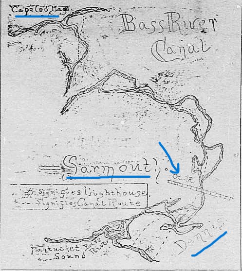
The 1891 Bass River Canal map. The arrow points to where the Bass River Bridge was.


The Bourne-Sandwich canal was still seen as less feasible which gave the Bass River Canal hope in 1893 when it was yet again submitted as a petition. In June 1894 the Massachusetts House voted in favor of the Bass River Canal, and a year later the company secured a charter. Plans were in place to begin construction which was estimated to last two years and cost between $5-8 million ($176-282 million).

Sadly this is where the project died a death. After four years the charter had been dissolved and no work was ever done on the proposed Bass River Canal. In 1899 the charter for building a canal was granted to the Boston, New York, and Cape Cod Co. which intended to build the canal between Bourne and Sandwich.

For several years after the Bass River Canal Co. attempted to regain their own charter for their canal. Finally in May 1904 the Massachusetts State Senate dealt the company its death blow by flat out rejecting the Bass River Canal proposal. The doorway was open and in 1904 August Belmont purchased and reorganized the Boston, New York, and Cape Cod Co.

Sunset at the Cape Cod Canal.


The rest is history. Work began on the Cape Cod Canal as we know it on June 19, 1909, opening on July 29, 1914. The Bass River Canal idea, much like Jeremiah’s Gutter before it, faded into history. Or did it?

In 1966 rumblings began of a potential look into the feasibility of a Bass River canal. There was even a proposal in February 1966 for $15,000 for a study into whether such a project could be done. However, nothing came from it.

In the end Jeremiah’s Gutter actually was used by boats. The Bass River Canal spent decades locked in legislation before being dissolved without even a spoonful of dirt being shoveled. It is interesting though to think of what Cape Cod would look like today with a Bass River Canal and the Scusset and Manomet Rivers still intact in Bourne and Sandwich.
-------------------------------------------------------------------------

Thursday, July 9, 2020

In My Footsteps: 4K Cape Cod - The Knob

Wednesday, June 27, 2012

In My Footsteps: Trip 129: Wareham, Massachusetts

In My Footsteps
Christopher Setterlund


Trip 129: Wareham, Massachusetts
June 14, 2012


            Though it is technically not considered a part of Cape Cod, Wareham shares many of the same qualities of a classic Cape village.  Wareham is considered the ‘Gateway to Cape Cod’ as the first town west of the Cape Cod Canal.  It was obviously once part of the Cape before the Canal was constructed. 
Tremont Nail Factory Building
            Wareham shares its name with a town in England and was originally settled as a part of the surrounding towns of Rochester and Plymouth in 1678.  Incorporated in 1739, the town mixes beautiful beaches and historic buildings with a highly developed retail center filled with stores and restaurants.  Perhaps most well known in Wareham is the Tremont Nail Factory which is the oldest manufacturer of nails in the country, established in 1819.  The Old Company Store across the street from the factory is a popular spot as well.  It is an old time gift shop with penny candy and gourmet foods as well. 
Old Company Store
            Located a few doors down from the Tremont Nail Factory is another well known spot.  The Benjamin Fearing Tavern Museum was originally the home of Isaac Bump, a local miller, when it was first built in 1690.  It became the tavern in 1747.  Besides being one of the oldest homes in Wareham it has also been the site of possible paranormal activity.  In 2008 researchers from a local show Spooky Southcoast conducting hours of tests in the old tavern.  Though the results were somewhat inconclusive it definitely will make any visitor keep their eyes and ears opened.
            If you take Route 6 west into Wareham it does not take long to find a beautiful scenic spot.  A right turn onto Red Brook Road leads you to Buttermilk Bay and the adjoining Little Buttermilk Bay.  These bodies of water are great for fishing and the Bourne Bridge hovers above the tree line which gives perspective as to how close spots like these are to major highways.  Route 6 continues west and crosses the Agawam River before hitting the retail center of Wareham.  This river has been one of the most important herring rivers in the state since 1632 and is one of the few remaining operated herring runs left in Massachusetts.
Fearing Tavern Museum
            The Wareham Town Hall is located near the retail center as Route 6 becomes also known as Marion Road.  It stands in front of the middle school and across the street from the Wareham Free Library.  It looks the part of an old government building in amongst the modern retail stores.  There is also a really nice railroad station located behind Main Street and along the Agawam River.  There is still freight rail service in Wareham but at this time no passenger service.  Of course for families coming to visit there must be a stop at Water Wizz, the popular water park located near the Cranberry Shopping Plaza on Rt. 6.
            Much like Cape Cod, Wareham has its share of smaller villages that make up the bigger town.  One such village is Weweantic.  A left turn from Rt. 6 onto Cromesett Rd. will take you out onto this tiny peninsula that sticks out into Buzzards Bay.  Bordered on the east by Marks Cove and on the west by Pattons Cove and Briarwood Beach, Weweantic is a great little detour off of the main road and sports tremendous views from all sides.
Buttermilk Bay with the Bourne Bridge on the right.
            Another beautiful spot is a little harder to get to if it is to be fully appreciated.  Stony Point Dike is a man made strip of land that stretches out a mile into Buzzards Bay.  It is what was created by the dredging of the Cape Cod Canal.  It is located at the end of Great Neck Road but can be seen on the horizon from Little Harbor Beach.  For kayaking lovers it is a perfect trip, just over a mile, from the beach to Stony Point.  It should be noted that swimming and paddling on the Canal side of Stony Point is prohibited and dangerous.
Wareham gives you all that you could want in a seaside town.  There are beautiful beaches, historic buildings with fascinating stories, and there are also plenty of shopping areas for those that are not as into nature and history as I am.  These spots are so close to the Cape but can at times be overlooked by people on the way to New Bedford or Providence.  I highly recommend taking a day trip to discover Wareham.  Have fun and happy traveling!


Directions: Buttermilk Bay: From Rt. 6 heading west, turn right onto Red Brook Rd., continue onto Head of the Bay Rd.  Turn right onto Old Head of the Bay Rd.  This gives you the best view of Little Buttermilk Bay and Buttermilk Bay through Gibbs Narrows.

Tremont Nail Company: from Rt. 28 heading west turn left at Mayflower Ridge Dr., then quick right at Elm Street.  Old Company Store is directly across the street.  

References:    Tremont Nail Company
                       Water Wizz
                       Wareham Historical Society
                       Wareham - Official Town Page
                       Wicked Local.com - Something to Fear at the Fearing Tavern?
       

Friday, January 28, 2011

In My Footsteps: Trip 99: New Bedford, Massachusetts


In My Footsteps
Christopher Setterlund


Trip 99:  New Bedford, Massachusetts
December 2, 2010


            An historic seaport matched in importance only Gloucester that’s what New Bedford is.  Nicknamed ‘The Whaling City’ it was one of the largest whaling ports in the world during the 19th century.  That history is still a big part of what makes New Bedford a popular destination for travelers.  However the whaling history is only the tip of the iceberg as I was pleased to learn.  In addition to the New Bedford Whaling Museum there are forts, historic homes, and some extraordinary cobblestone streets.
Fort Rodman, Clarke's Point Light on top.
            The first place I visited when I arrived in New Bedford was a pair of old forts strategically placed on Clarke’s Point, the southernmost point of the city which sticks out into Buzzards Bay.  Fort Taber is a living breathing artifact.  It is two buildings, an earthen fort and granite fort side by side along the breezy shores.  The earthen fort was built during the Civil War in 1861.  It was built first as Governor John Andrew and Mayor Issac Taber could not wait for state or federal aid to help build the granite fort at the dawning of the Civil War.
The much larger, granite structure next to the earthen fort was started shortly thereafter; the United States War Department stopped construction in 1871.  It was locally finished in 1898 and named Fort Rodman after Civil War Lt. Col. Logan Rodman of New Bedford.  The Clark’s Point Lighthouse, which once stood alongside the granite structure, was placed on the second tier of the fort and is easily visible today.   The many windows of Fort Rodman have been sealed shut using brick.  However there have been holes chipped into these bricks making it possible to see inside and even for me to get my camera inside to snap photos of the courtyard.
Garden at Rotch-Jones-Duff Museum
Despite being two different buildings with two different names, the area is usually mistakenly simply called Fort Taber.  The granite fort is kept under lock and key but the earthen fort can be entered, though beware as vandals have sprayed graffiti inside and littered as well.  It is not as large as Fort Revere in Hull but walking through the darkened tunnels of this fort is creepy yet exhilarating.  You can almost feel what it was like when the fort was active 150 years ago.
Butler Flats Light
Not to be missed is a spark plug lighthouse known as Butler Flats Light.  It is quite a ways out if you walk the long pier which stretches out from Clarke’s Point.  It is a lot closer to shore as you’re leaving the forts.  There are a few spots to stop along East Rodney French Boulevard where you can get a much better view of the lighthouse at the mouth of the Acushnet River.  Built in 1898 Butler Flats Light was the replacement for Clarke’s Point Light.  That lighthouse stood along the shore from 1799 until 1869.  Once Fort Rodman had taken shape a new wooden structure was built on top of it where the lantern was relocated.  The stone lighthouse tower stood until 1906. 
One really nice historic home in New Bedford is the Rotch-Jones-Duff House.  It was built in 1834 for a whaling merchant named William Rotch Jr.  The house has three names, one for each of the families that lived at the house at different times.  The Rotch family obviously when it was first built in 1834, the Jones family starting in 1851, and the Duff family starting in 1935.
New Bedford Whaling Museum
The house has a more golden yellow color which looked impressive with the sun softly shining on it.  However the best part of this twenty-eight room mansion actually is outside where the amazing garden resides.  The garden encompasses a full city block and even in the late autumn it was a sight to behold.  It is said that the current garden is more in line with the time that the Jones family lived here.  There is a knee-high hedge maze which wraps around patches of beautiful flowers, some of which were still colorful even at this late stage of the season.  I would put this location on my list when planning a visit to New Bedford in the warmer months.
One area that needs no time frame to be enjoyed is a virtual time warp back to the 19th century.  In the historic district of New Bedford, near the waterfront, there is a block of streets which are still lined with cobblestones.  Just walking these streets is a magical experience but when that is coupled with the fact that nearly every building you pass is significant it makes it a nearly perfect place to explore.
The Whaleman's Chapel from Moby Dick
Of course most people know of the New Bedford Whaling Museum, established in 1903, it is probably the most visited spot in the entirety of New Bedford.  Inside there are more than 200,000 artifacts from the past few centuries which give a complete history of the whaling industry in New Bedford and the entire ‘Old Dartmouth’ area.  This museum is a must see for all visitors.
The home of another rich whaling and banking industry pioneer Andrew Robeson is famous for having its 500 ton frame moved some 400 feet in 1978.  The federal-style(brick) home built in 1821 was in line to be torn down in the name of progress but it was saved by the Waterfront Historic Area LeaguE(WHALE).  It was painstakingly moved inch by inch from Second Street and turned ninety degrees before it came to rest at its current locale on Williams St.  That story is enough to warrant a visit when passing through New Bedford.
The cobblestone historic district has so much to see that it would be impossible to list it all.  I can only tell you to park and walk, you will be sure to find some amazing places.  Of course the Whaling Museum needs to be seen and don’t forget the historic forts out at Clarke’s Point.  New Bedford is one of the most historic seaports in the country and I can’t recommend a visit enough.  Have fun and happy traveling!    

For more In My Footsteps items follow my Twitter Feed, view more photos at the In My Footsteps fan page on Facebook, or visit my homepage at ChristopherSetterlund.com.   Thanks for reading! 


Directions:  Fort Taber/Rodman: From I-195 West take Exit 15 into New Bedford.  Follow John F Kennedy Memorial Highway until you need to bear right onto Rodney French Blvd.  The Fort Taber/Rodman site is on the right at the end of the road.
            Rotch-Jones-Duff Museum:  From I-195 take Exit 15, continue onto JFK Memorial Highway for 1.7 miles, turn right at Union St., turn left at 7th St., follow it .2 miles to house on right.
            New Bedford Whaling Museum:  From I-195 take Exit 15, continue onto JFK Memorial Highway for 1.5 miles, turn right at Elm St.  Take the 2nd left onto 1st St., museum is on left.  


            New Bedford Whaling Museum

Friday, January 21, 2011

In My Footsteps: Trip 97: Dartmouth, Massachusetts

In My Footsteps
Christopher Setterlund


Trip 97:  Dartmouth, Mass.
December 2, 2010


Demarest Lloyd State Park
            One part seaside village and one part college town, Dartmouth has the best of both of those worlds and much more. Dartmouth is primarily known as the home of one of  the University of Massachusetts campuses.  However, the ‘college town’ part of Dartmouth is only a small piece of what makes up this seaside town.  It was first settled in 1652, purchased from the Wampanoag chiefs Massasoit and Wamsutta by Plymouth Colony.  It was subsequently sold to the Quakers because they wanted a place to live outside of the strict Puritan laws of Plymouth Colony.  There are several Quaker Meeting House’s located in Dartmouth’s borders that remind citizens and visitors alike of the town’s roots.
            The first place I stopped at was Demarest Lloyd State Park along Dartmouth’s southern coast on Barney’s Joy Road.  In the offseason the gate is closed and so I had to walk down to the beach which faces Buzzards Bay.  The walk was nice though as the road is paved and the weather was not too cold.  There is a picnic area on the right as you head toward the beach.  Although there aren’t any places to park next to the picnic area they would really only be used when it is warm so that should not stop anybody from partaking in the beautiful picnic area scenery.
Oxford Creamery at the Bucket
            The beach is small and filled with small rocks but it has spectacular views.  To the east there is Mishaum Point and the Slocums River empties into Buzzards Bay here.  To the west the land slopes out toward Horseneck Beach in neighboring Westport.  The river may empty here but there is a much better place to enjoy the sights of Slocums River.  Russell Mills Landing on Horseneck Road was where I stopped to get a good view of the river passing through.  There is a playground for the children and I got to see a huge flock of ducks meandering around in the water.  While I can’t promise you the ducks the scenery at Russells Mills Landing is worth a look.  The name Russells Mills will appear again later in this article.
            Apponagansett Park on Gulf Road is another place filled with great maritime scenery.  The name Apponagansett is also the name of one of the previously mentioned Quaker Meeting House’s located in Dartmouth.  The park is rather small, facing Apponagansett Bay, and connected to South Dartmouth by a long drawbridge.  There were still some boats in the water as well despite it being well past the end of the season.  However despite the boats, a gazebo, and drawbridge, there was something else that caught my eye here above all else.
Looking across Apponagansett Bay to S. Dartmouth.
            It was a twenty-foot tall brown ice cream bucket that fascinated me the moment I pulled into Apponagansett Park.  Oxford Creamery at the Bucket, also known as Gulf Hill Dairy Ice Cream is a unique ice cream shack that must be extremely busy during the summer.  I imagine that there must be lots of people who come from miles away just to see this one of a kind landmark in addition to partaking in the delicious treats it serves.  It was during my time at places like this where I had to remind myself that this was a college town you’d be hard pressed to find evidence of that fact once you get out of sight of the UMass campus.
            The Apponagansett Friends Meeting House, located on Russell Mills Road was originally built in 1689 with the current structure having been erected in 1790.  As I previously said it is one of several Quaker Meeting Houses in Dartmouth and this one sits stoically on a hill overlooking the road and hiding an old cemetery behind it.  I am not one for wandering through cemeteries but it felt like I was taking a walk through the history of the town as I did.  Granted it is not for everyone, but those who don’t get creeped out easily might enjoy it.
            The village of Russells Mills is a large part of the history of Dartmouth.  I have already mentioned it when speaking of the landing which sits next to Solcums River.  However, there is an historic district in the western part of the town that houses some neat old buildings.
Russells Mills Schoolhouse-Library c. 1871
            I stopped at the Russells Mills Library-Schoolhouse built in 1871.  Doubling as both in the past it is now used solely as a library.  Try as I might I have had trouble finding out the importance of the Russells Mills name so much of the history of this area is unknown to me.  There was a donkey hitched up behind the building which was a bit surprising to me and was one of the little moments I tend to run into which make each trip unique.  I hope that maybe someone reading this might have some much needed information about the Russells Mills name for me.
            Dartmouth is definitely a mixture of many places.  One part college town and one part seaside village it is all together a great spot to visit.  I would imagine that it would be even more fun to visit Demarest Lloyd State Park and Oxford Creamery at the Bucket at Appongansett Park during the summer.  Still I enjoyed my time in Dartmouth and think any potential traveler will as well.  Have fun and happy traveling!

For more In My Footsteps items follow my Twitter Feed, view more photos at the In My Footsteps fan page on Facebook, or visit my homepage at ChristopherSetterlund.com.   Thanks for reading! 


Directions:  Demarest Lloyd State Park:  From I-195 take Exit 12, turn right at Faunce Corner Dr., continue onto Old Westport Rd.  Turn left at Chase Rd., follow it 3.5 miles, turn right at Russells Mills Rd.  Continue onto Horseneck Rd., continue onto Barney’s Joy Rd.  Park entrance is 1 mile up on left.
            Apponagansett Park:  From I-195 take Exit 12, turn right at Faunce Corner Dr., turn left at State Rd., turn right at Tucker Rd.  Follow it 3 miles, continue onto Russells Mills Rd.  Continue onto Bakerville Rd.  Turn left at Gulf Rd., Park is on left 1.3 miles.

            Oxford Creamery.com

Saturday, January 23, 2010

In My Footsteps: Trip 8: New Bedford, Fairhaven, Mattapoisett

In My Footsteps


Christopher Setterlund

Trip 8: Fort Taber/Rodman – New Bedford, Mass.

Fort Phoenix – Fairhaven, Mass.

Ned’s Point Light – Mattapoisett, Mass.

January 22, 2010


Massachusetts being one of the thirteen original colonies is a state rich in history. Every town in the state has its own list of historical places to visit. There are so many places in fact that it is possible to visit any of Massachusetts towns several times and still miss some amazing historical places. There are three mentioned here today that are must see, but they are by no means the last I will seek out.

Located only a half hour from the Bourne Bridge, New Bedford is overflowing with historical places. Deep in the tradition of the sea the New Bedford Whaling Museum, established in 1907, is normally the first spot circled on any itinerary as well it should be. The cobblestone streets and old-time looking shops in the surrounding area make it feel as though you have traveled back to another time. After visiting the museum there are many other places just as rich in significance in New Bedford. One such place is located at the end of Rodney French Boulevard on Clarks Point along Buzzards Bay.


Fort Taber is a living breathing artifact. It is two buildings, an earthen fort and granite fort side by side along the breezy shores. The earthen fort(left) was built during the Civil War in 1861. It was built first as Governor John Andrew and Mayor Issac Taber could not wait for state or federal aid to help build the granite fort at the dawning of the Civil War.


The much larger, granite structure(right) next to the earthen fort was started shortly thereafter; the United States War Department stopped construction in 1871. It was locally finished in 1898 and named Fort Rodman after Civil War Lt. Col. Logan Rodman of New Bedford. The Clark’s Point Lighthouse, which once stood alongside the granite structure, was placed on the second tier of the fort and is easily visible today. Despite being two different buildings with two different names, the area is usually mistakenly simply called Fort Taber. The granite fort is kept under lock and key but the earthen fort can be entered, though beware as vandals have sprayed graffiti inside and littered as well. If you take a step back and close your eyes you can imagine the soldiers training on this spot more than a hundred years ago.


Only five miles north of Fort Taber is an even older piece of American history. Located along the water in Fairhaven, and within sight of Fort Taber is Fort Phoenix. This spot was built during the American Revolution in 1775. It was destroyed by British troops in 1778 but was rebuilt so quickly that it was given the name Fort Phoenix(right) after the mythical bird. In 1812 it was enlarged under the supervision of the future ‘Father of the Military Academy’ at West Point, Sylvanua Thayer. It helped repel an attack by the British HMS Nimrod in 1814. It remained in use during the Civil War with Union troops rotating between Fort Phoenix and Fort Taber. Though not used since 1876, Fort Phoenix still bears the look of an active military institution with five 19th century cannons perched facing over the waters of Buzzards Bay as if ready for an oncoming battle. The site is open year round and has a tremendous breakwater walk with a view of Palmer’s Island Light located on a small island in the middle of the harbor.


About seven miles east, in the small town of Mattapoisett, there is yet another piece of history. On the shore of Buzzards Bay, at the mouth of Mattapoisett’s harbor, sits Ned’s Point Lighthouse(left). It was built in 1838 at the urging of former President, and at that time Massachusetts Congressman, John Quincy Adams. It had been rushed and poorly built at first, needing several rounds of improvements up through 1888. The wooden light keeper’s house was loaded on a barge and floated across Buzzards Bay to Wing’s Neck Light in Bourne in 1923. Russell Eastman, the last keeper at Ned’s Point, rode in the house across the bay on the day. Decommissioned by the Coast Guard in 1952 the light became active again in 1961. The thirty-nine foot stone tower is open for a few hours Thursdays during July and August but the grounds are open all year long.

Massachusetts is filled with history that dates back nearly 400 years. It is impossible to visit any of the 351 cities and towns in the state and not find one if not several amazing historical landmarks. You don’t even have to enjoy history to appreciate these sites mentioned above. It is much different than studying a book when the places themselves are brimming with life as you stand before them. I recommend each of these places be visited but they don’t have to be all in one day! Have fun and happy traveling!

Directions: Fort Taber/Rodman: From I-195 West take Exit 15 into New Bedford. Follow John F Kennedy Memorial Highway until you need to bear right onto Rodney French Blvd. The Fort Taber/Rodman site is on the right at the end of the road.

Fort Phoenix: From I-195 West take Exit 18 into Fairhaven. Turn right to take Rt. 240 south. A little more than a mile turn right onto Bridge St. Bear right onto Rt. 6/Huttleston Ave. Turn left on Main St.; left onto Church St.; and right onto Fort St. Fort Phoenix is on the right as you approach the beach.

Ned’s Point Lighthouse: From I-195 West take Exit 19A. Turn right into Mattapoisett. Bear right onto North Street, follow for a mile and a half and turn left onto Water St. which becomes Beacon St. This road becomes Ned’s Point Rd. without any turns. Follow it to the park where the lighthouse is located.

References: Fort Taber/Rodman History

Fort Phoenix History Blog

Ned's Point Light Virtual Guide

New Bedford Whaling Museum

Thursday, January 21, 2010

In My Footsteps: Trip 6: Cape Cod Canal - Cape Side

In My Footsteps
Christopher Setterlund

Trip 6: Cape Cod Canal – Cape Side
January 20, 2010


With so many destinations on the map when it comes to visiting Cape Cod, there are some very obvious ones that tend to get overlooked. One such place is seen by every single person who ever visits the Cape: the Cape Cod Canal. Stretching just over seventeen miles in length from Cape Cod Bay to Buzzards Bay and crossed by three bridges the Canal is a man made miracle that gets lost sometimes in the allure of the many beautiful beaches and shops of the Cape. This article is going to be all about the Canal and what there is to see along its shores. Being far too long it will be divided into an on Cape article and an off Cape article.

I began at the mouth of the Canal on the east side which empties into Cape Cod Bay. After a short walk across a very rocky beach I was lucky enough to arrive at the edge of the Canal just in time to watch a large ship from the Great Lakes area pass through and head out into the bay(left). At a maximum width of 540-feet the Canal sees over 20,000 ships pass through its waters annually.

Located a few hundred yards from the bay end of the Canal is a Power Plant owned and run by the Atlanta-based energy company, Mirant. A trail way leads from the mouth of the Canal back toward one of the visitor’s centers. Directly across from the visitor’s center is the Coast Guard station as they, along with many fishermen, operate out of the small harbor at the Sandwich Marina.
Route 6A is the best way to follow the Canal. There is a service road for authorized vehicles and bike trails running along either side of the waterway but most of the sights along the Canal can be driven to without a problem. Traveling along 6A, the first major sight is that of the Sagamore Bridge. Opened in 1935 and spanning 1,408 feet across the Canal, this bridge is the way to get onto the Cape from Boston and points north as it continues seamlessly from Route 3 to Route 6. The ‘Sagamore Flyover’ project, completed in 2006 replaced a rotary that caused traffic to become severely congested with an easier to navigate system of roads. 


Route 6A becomes Sandwich Road during its run along the Canal. Just before the Bourne Bridge rotary comes into sight Sandwich Road bears right. Follow this road and you will find yourself stepping into a hidden piece of Cape Cod, and United States history. Sandwich Road travels along a more secluded section of the Canal, passing directly under the Bourne Bridge(right). Unlike with the Sagamore Bridge there is a designated recreation area next to the bridge allowing visitors to park. People can get out and walk along the Canal while listening to the rush of highway traffic passing overhead. It is a soothing sort of hum. There are active railroad tracks which also pass along the Canal and they should be watched in case of trains. The bike path can be used to walk on and on warmer days it is highly recommended and highly populated by bicyclists, runners, and skaters.
Sandwich Road continues and it is along here that the visit to the Canal takes on a more historic twist. After passing by the Jonathan Bourne Library a right hand turn down Perry Avenue will lead you to the Aptucxet Trading Post museum. Built in 1627 it was the first trading post used by the fledgling Plymouth Colony. The building that stands is a replica of the original, but the museum houses excavated pieces of the nearly 400-year old building inside. Not to be missed as well sitting less than a hundred feet from the Aptucxet Trading Post museum is the Gray Gables railroad station. It was created for President Grover Cleveland whose summer home in Bourne was named Gray Gables. The building was moved to the Aptucxet grounds in 1976.

Aptucxet Road leads to Shore Road via a surprisingly beautifully painted overpass. Turn right and follow Shore Road to Bell Road and the third and final bridge along the Canal. The railroad bridge, built in 1935 and crossing the Canal near Buzzards Bay, was the largest vertical lift bridge in history when it was originally built. It is still right up there today. When raised it has a clearance of 135-feet. Near the Buzzards Bay end of the Canal sits a small cove where on this day hundreds upon hundreds of ducks and other water fowl congregated. No trains passed during my stop here but watching the railroad bridge(below) move is a spectacular sight to see.

Not to be lost in all of the sights and activities along the Cape side of the Canal is the fact that the entire waterway was man made. It is amazing to think of how technology was different when the project began nearly one hundred years ago. That information makes the whole scope of the trip even more remarkable. Stay tuned for the second part of this article focusing on the off-Cape side of the Canal. Have fun and happy traveling!

Directions: Cape Cod Bay end of the Canal: On Cape, take Rt. 6A into Sandwich, take a right onto Tupper Rd. to Town Neck Rd. Off Cape, take Exit 1C after crossing Sagamore Bridge, turn right onto Sandwich Road. Follow it just over a mile and take a left onto Tupper Rd.
Bourne Recreation Area: Follow Sandwich Rd. west along Canal. Bear right before Bourne rotary. Recreation area is right turn at foot of bridge.

Aptucxet Trading Post & Gray Gables: Follow Sandwich Rd. west along Canal, bear right before Bourne rotary, follow Sandwich Rd. into Bourne. Turn right onto Perry Ave., a quick left onto Aptucxet Road. The grounds are designated by a windmill and sign.
Railroad Bridge: Follow Sandwich Rd., turn right onto Shore Rd. Right turn onto Bell Rd. less than 1 mile away. Follow it to the Canal.

                     Cape Cod Canal Chamber of Commerce