Pages

Showing posts with label bass river. Show all posts

Monday, August 24, 2026

Initial Impressions 2.0 Blog #135: A Big Success, Glitter Face, Pack An Extra Chin, etc.


1. I was so grateful and a bit overwhelmed to see the budget goals for my feature film debut, The Cabin, get met through GoFundMe. I wanted to say ‘we’ did it, but in all honesty it was my family, friends, and total strangers that came through. In the end, I kicked in a little to get us over the hump, but the vast majority was from others. In a fun twist, one of the locations we’re going to shoot at is now going to be ours free of charge. Yes, that means our budget has dropped, which is a good problem. I said if, after everything, there is a little money left, I will just absorb it back into my bank account. However, with the budget set comes the actual action. I am thankful but also feel a bit of good pressure to help to make a film worthy of all of those who have shown their support. In the back of my mind, I had a fear that the fundraiser would be a bust and I’d have to cough up thousands of dollars to make my dream come true. I would have done it, but I am so much happier that I don’t. There will be so much more to come in terms of updates about The Cabin. For now, all I can say is thank you to those who donated to the fundraiser. Your support means the world to me.


2. In life, you need to try to learn to not get too high on good days and not too low on bad ones. I say that because after a string of amazing days, capped off by reaching the budget goal on The Cabin, I had a cold slap of reality in the face. Nothing will dull your good vibes quicker than a text from your bank saying there was an attempted fraudulent purchase on your debit card. I went from a peaceful, easy feeling to sitting in the sad cafe, sorry that was a couple of Eagles puns. Luckily, I am so regimented and boring with what I spend money on that my bank instantly caught it. Some ass hat tried to charge $350 for some crap but got foiled. So I didn’t lose any money but had to immediately cancel my debit card. Next is the process of getting a new one sent, which could take until the middle of next week. I am working on getting a digital card and finally starting to use Apple Pay through my phone. The only issue with that is that I am forced to have a passcode on my phone to protect that debit card. That’s right, I have had my phone without a passcode for years. It is never far from me, so I never felt the need. On one hand, I am so pissed that some scumbag tried to get my money. Get a job, you waste of human life. On the other hand, I am so grateful that my bank foiled this attempt. In some ways, and this might be the middle-aged man talking, but I miss the days of everything being cash and digital banking not being everywhere.


3. One interesting scenario when it comes to the filming of The Cabin has to do with actually getting there. Do I drive my car, or do I rent one? On one hand, driving my own car saves hundreds of dollars over renting one. On the other hand, I just had some exhaust work done on my car, and although I trust driving it locally, and probably up to an hour from home, I don’t know if I trust driving it eight hours each way. I know my car needs some more work done on it to get it to closer to 100%, or at least as close as a car nearing 170K miles can get. I don’t want to have that work done until the new year, so it does make sense to spend the money to drive 1,000+ miles in total over the course of a week. I was hopeful that my AAA membership would give me some great discounts on renting a car. Nope. I guess I thought renting cars was cheaper than it is. Renting a vehicle for what would be six days costs the same as the hotel room I’ll be getting out there. That includes whatever discounts AAA would give me, which isn’t much. The funny part is that of all of the vehicles I’ve been looking at to rent, the cheapest are SUVs. It’s funny because, thanks to gas prices being as high as they have been in years, any savings I’d get on renting an SUV would immediately go out the window when I had to pay close to $5 a gallon for gas on a vehicle that gets half as many miles per gallon as my car. Update: Yes, I ended up renting a car.


4. So I had to cancel my debit card and ask for a new one to be sent to me. Fine. Not much I can do but wait, right? Wrong. An interesting little side quest in this latest fraud saga was learning about digital debit cards and also learning how to use Apple Pay. The debit card took seconds to get, so that was good. Next was setting up Apple Pay to include that card. I have had iPhones since 2011 and have never used the Wallet app for digital payments or storing cards, passports, etc. I figured approaching fifty was the right time to learn. It turns out it is way easier than I could have imagined. The literal next day after canceling my old debit card, I was able to use the new card to get gas via Apple Pay. Sure, swiping my card or using the chip reader didn’t take long, but Apple Pay cuts that time down even more. In less time than it takes to sneeze, I had my card accepted and was pumping the very overpriced but very needed gas into my car. One funny little twist to the Apple Pay story is that it has forced me to start using a passcode to open my phone. What’s that? You can’t believe I never used a passcode? My phone in the past 15 years has rarely been out of my sight, so it never seemed necessary. I grew up in a time when the majority of people still left their doors unlocked, so I guess I’m old-fashioned. Anyway, in order to have Apple Pay working, you have no choice but to use a passcode to protect your money, which makes total sense. I’m just getting used to the major inconvenience of typing six numbers in two seconds to open my phone. In the end, though, if it keeps my money safe, I can deal with it.


5. I think I have earned my reputation as the ‘fun uncle’ in my 27 years of being one. I tend to let my nieces and nephews do whatever they feel like, unless it’s super dangerous. Five of my six nieces and nephews are grown up to a point where they have their own friends and lives, and my time has been reduced a lot. It’s just what happens in life. So when I get the chance to spend some time with my youngest niece, Sylvie, you can bet I am taking advantage of the chance to be fun and foolish. The latest such chance was this week. My mom had gotten Sylvie some glitter makeup, and once she saw what it looked like, I knew it was only a matter of time until I was wearing it. Sure enough, she laughed while coating my face in glitter. This was accompanied by a 2nd place medal she had won at summer camp. Not wanting her to feel bad, I kept the medal and the glitter on even after she left. I went to the store after I left my mom’s, and even though I took the medal off, I did go inside complete with a glitter face. Seeing how much my face shined at my mom’s, I can only imagine what people thought seeing me in the store. Oh well, the price you pay for being the fun uncle is walking into public places with glittery makeup on your face. I wouldn’t have it any other way.

No, I wasn't this glittery, but there is always next time.


6. Sadly, I am now at the age where I can end up with some sort of pain or injury and have no memory of what caused it. This week it is my right shoulder. It has been painful to fully extend overhead. Tracing steps backward, I threw a pair of 10# slam balls with a client at work one day this week, but that wasn’t the cause. I also demonstrated a kettlebell windmill exercise with another client (this involves keeping your arm fully extended overhead while simultaneously hinging your body sideways away from that arm). That also wasn’t the cause. All I can think of is that I slept on that shoulder awkwardly, woke up with some pain, but didn’t pay attention and kept going about my day. I wish I had a better injury story. I wish I had tackled some guy that stole a woman’s purse, or hurt it dragging a stranded dolphin back into the ocean. Nope. I slept wrong. Yay, soon it will be that I threw out my back coughing or something dumb like that. Oh wait, it was only a few years ago that I threw my back out leaning forward to look at sliced meats in a deli, so yeah, we’re already there.


7. I’ve said it before, I’ll say it again: If you can’t figure out how to use self-checkout at the supermarket, go to a register with an actual person. This ends up being an older person most of the time. Lo and behold, it was again this week. A guy who had to be in his mid-70s had invariably messed up scanning his items at self-checkout. The store seemed to be short-staffed, so as the light was blinking, there wasn’t anyone immediately coming over to help. Then it happened at the next register, which was shockingly being operated by another old person. Rather than walking over to the service desk, which was about ten steps away, or, I don’t know, being patient for a few moments, these old bags started waving their arms like they were signaling a passing plane while stuck on a deserted island. God forbid an old person show sympathy for the short-staffed store. After a few seconds of waving like idiots, the old man started whistling like he was calling his dog at the park. Seriously, it was incredibly annoying and embarrassing. I was scanning my items with no issue since I had a good grasp on technology. All the while, this pair of old bags were doing a talent show routine. I wanted to tell them they should go to a regular register, but I’m sure they’d have just blamed the machine instead of their own incompetence. After an employee came over and sorted things out, one of the old people immediately caused the register to go off again. Naturally, they blamed the machine. I’d say they should do home delivery, but they’d probably give the wrong address and never get their stuff.


8. Three weeks ago I first shot a video of the current demolition of the Bass River Bridge on Cape Cod. They are slowly removing the westbound lane. That lane will be totally rebuilt wider. Once finished, work will begin on the eastbound lane. All the while, the bridge will still be in operation, which feels a bit shaky. I have heard the bridge is safe to stay in use even while being torn down. As of this week, half of the side barriers of the westbound lane have been removed. I stopped at the neighboring river park during a run so I could get some video of it. Since it’s still the heat of summer, the traffic gets pretty crazy on the bridge. I was able to run across the bridge faster than most vehicles could cross. I am not sure how long it will take to finish removing the barriers, but I am curious as to what the next step in the demolition process will be. The bridge functions fine without the barriers. However, once they start removing the pavement, then what? Regardless of the progress, it appears as though it will be about five years until the entirely new Bass River Bridge opens. Here is a video I shot this week so you can see how far they’ve gotten.


9. Filming unofficially began for The Cabin this week. I recorded three audio-only scenes with my buddy Steve, who plays the main character’s best friend. The setup was simple. Steve sat in front of the microphone with a soundproof box around it. It’s the same setup I use for my podcast. I was in charge of recording on my laptop and read the other lines in each scene. The awkward part came when intentionally placing spaces in between dialogue. After each character spoke, we would pause for a second or two. The reason for this is so that in post-production it will be easier for the editor to remove my voice and put in the actual actor playing the main character. It ended up being a pretty easy read-through and took maybe a half-hour total. I will be interested in hearing the finished product, as I was tempted to edit Steve’s dialogue to make it sound like he was on a phone. I’ll leave that stuff to whoever the editor will be. There are still two scenes to film before going off on location. Both of those are on video. I will end up standing behind the camera to run lines and also just rein in my excitement over this dream project starting to take shape.


10. Naturally, as I draw closer to heading out to Pennsylvania for The Cabin and get my hotel reservation set, I begin scoping out the area to see what there is to do and see. Now, with the town being small, there aren’t tons of attractions, but there are tons of places to eat. I am staying in one town, and we will be doing a lot of shooting in the next town over. There are lots of great-looking restaurants there as well. It’s a strange combination, as I technically am going on vacation, but in reality will be working more hours than I do in a typical work week on Cape Cod. I won’t have loads of time to explore, so I am guessing most of the adventures I have away from the movie shoot will consist of eating. I have already resigned myself to the fact that I will be in need of a serious cleanse upon my return. I mean, there is a Chinese food buffet a five-minute walk from my hotel, so why fight it? My hope is that the 12+ hour shooting days will help me keep burning calories, but I’m not getting my hopes up. The main souvenir I bring back from the filming may be an extra chin.


Me when I get home from the movie shoot


Sunday, April 28, 2024

The Long Road of Yarmouth's Bass River (Smuggler's) Beach


Today much of the coasts of the United States are a mix of public and private beaches. The rich own strips of sand in front of their property while cities and towns purchase plots of land for the average everyday people to use.

The coastlines were not created as public or private. Many steps go into creating a public beach. Things like legal ownership, planning, regulations, zoning, and meetings are parts of what takes an area from an inconspicuous stretch of sand to a beach packed with people in summertime.

Though no two are exactly the same one example of land going from private to public resides on Cape Cod. At the mouth of Bass River, a waterway running in between the towns of Yarmouth and Dennis, there are popular beaches on both sides.

They both went from private to public. On the Dennis(east) side of Bass River sits Davis Beach. Known more commonly as West Dennis Beach this stretch of sand nearly a mile and a half in length was owned for decades by Charles Henry Davis. He had deep connections to Cape Cod including the creation of America’s first traffic circle at the meeting of River and Pleasant Streets in the Bass River section of South Yarmouth.

America's first traffic circle in South Yarmouth.


Davis at one point it was said could walk from Nantucket Sound on the south coast of Cape Cod all the way to Cape Cod Bay on the north side and never leave the property he owned. This included all of what is today West Dennis Beach. The acquisition of this pristine set of sand was simple and straightforward. Davis sold the property to the Town of Dennis shortly before he died in 1951 for the cool sum of $50,000($589,900 in 2024).

West Dennis Beach has a story that is for all intents and purposes simple and clear-cut. Across Bass River in Yarmouth, the beach has a slightly more complex story. It includes bootlegging, giant resort hotels, and more transfers of ownership than one might expect.

Present-day Bass River Beach began as the property of Joseph P. Phelan. Born in Ireland in 1888 Phelan came to America and settled in Fall River, Massachusetts. He was a successful businessman making significant money with his popular Cape Cod Shirt Company that he established in 1926.

Phelan purchased a triangular-shaped plot of land on the western side of the mouth of Bass River in an area known as The Point from Edward Gleason in April 1926. There he had a summer home constructed. In total, it was ten rooms including five bedrooms along with a wooden pier that stretched out into the ocean. The family’s arrival at the beginning of the summer was headline news in the local newspapers. When they weren’t at the home it was rented out with those renters also making the local news.

The beach at The Point grew substantially in size when in the early 1950s efforts were made to dredge Bass River. The spoils were piled onto either side of the mouth of the river.

For a few years, the piles of dredged sediment sat there. They were used as picnic areas, or for kids to play on. Eventually, Yarmouth used their spoils to fill in the marshland abutting the Phelan property. This also served to fill in the creek leading from nearby Run Pond to Nantucket Sound which was a bone of contention with some locals. In total, the Phelan property was thirteen acres of waterfront land.

During the early 1950’s the Town of Yarmouth had begun buying up beachfront property to be designated for public use. This included buying present-day Sea Gull Beach in 1951 for $25,000($300,000 in 2024), as well as the far smaller Englewood Beach for $9,000($106,000 in 2024) in 1952. As the Phelan property was only in use for a few months of the year rumblings began locally about the town buying that as well.


Bass River looking south toward the former Phelan property


In 1958 Joseph Phelan offered to sell the coveted property to the town for $150,000($1.62 million in 2024). Despite there being support for a new public beach the offer was deemed too high and the town passed. Talks of taking the property by eminent domain were voted down at the time. This left Harwich Port real estate broker John J. Taylor to swoop in and buy the land in September 1959 from Phelan for a far more affordable price of $80,000($858,600 in 2024).

The Town of Yarmouth had balked at the high price of the Phelan property. However when confronted with Taylor’s proposal for what to do with the land the town had wished they’d paid the price.

The plan was to subdivide part of the land for houses and leave a large tract of it to be used for a three-story, 180-room, waterfront resort hotel. This was rejected by the town which left the property in limbo.

Besieged with hurdles and roadblocks surrounding the thirteen acres of waterfront property Taylor sold the land to Sidney Tucker and Paul Lampros in August 1961 for $140,000($1.46 million in 2024). Only a few months later in March 1962 the Town of Yarmouth stepped in and took 10.5 of the thirteen acres of land by eminent domain. The Phelan summer home and a few lots of land surrounding it were left private. Tucker and Lampros sued the town in September 1962, arguing the land's value.

The proceedings dragged on in court until May 1964. However, once the jury got the case it took a mere twenty-eight minutes to award Tucker and Lampros a whopping $270,000($2.76 million in 2024) for the former Phelan property. This meant that essentially the Town of Yarmouth had paid nearly double the original asking price Joseph Phelan had offered which was seen as exorbitant.

Despite the long road and extra money paid, Yarmouth had its newest public beach. To cover the cost of the new beach as well as the new parking lot needed the town ultimately decided to start charging for parking during the tourist season. This was the start of buying beach stickers in Yarmouth.

Next up was the important task of naming the stretch of sand. In the local newspapers, it had been referred to as Phelan Beach since it was first offered for purchase in 1958. The name chosen was the on-the-nose name of Bass River Beach. However, locals rarely call it by that name.

In the six decades since Phelan Beach became Bass River Beach the area at the mouth of the river has been known more frequently as Smuggler’s Beach. But why? It is due to the stories of rum-running or bootlegging that took place in the area during Prohibition.


Did bootlegging take place at Smuggler's Beach?


The Smuggler’s Beach name becomes even more appropriate when coupled with the story of the Casa Madrid establishment. Located a few hundred yards from the beach on Run Pond Road the Casa Madrid opened in 1933 as a dancing and eating establishment. Only six weeks into its existence though it was raided by law enforcement and exposed as a speakeasy.

Did the liquor seized from Casa Madrid come from the nearby beach? One cannot say for sure, but the legend of Smuggler’s Beach draws heavily on that possibility.

From a summer home abutted by marshland to a hugely popular public beach the area formerly known as The Point in Yarmouth has taken a long road to get to where it is in the present day. It is an interesting dichotomy between the straightforward route of Charles Henry Davis’ property becoming West Dennis Beach and Joseph Phelan’s property becoming Bass River Smuggler’s Beach.

Sunday, January 14, 2024

Charles Henry Davis and America's First Traffic Circle: In Their Footsteps


     It goes by many names, rotary, traffic circle, or roundabout. Whatever it is called it is a common part of daily life not only on Cape Cod but all across the globe. As of 2022, according to Lee Rodegerdt's book Roundabouts: An Informal Guide, there were roughly 9,860 rotaries, traffic circles, and traffic-calming circles spread across America with Florida having the highest number. For as commonplace as these are today they had to start somewhere and that somewhere was Cape Cod and more specifically South Yarmouth. The man behind America’s first rotary was Charles Henry Davis, a man with deep connections to Cape Cod as well. 


America's first traffic circle at River and Pleasant Street in South Yarmouth, MA


     Davis was born in 1865 and lived in Philadelphia, Pennsylvania as a child. His father and grandfather were both involved in road construction which led to him later in his life becoming co-founder of the National Highways Association in 1911 along with Coleman DuPont. The first initiative of this organization was to publish a map of a 50,000-mile National Highways network for the country. It also began the system of numbering major state roads as can be seen all across America.

     Davis moved to South Yarmouth in 1902. He amassed quite a large fortune in the early years of the 20th century. This came about as his family owned several plots of land in the coalfield area of Harlan County in southeastern Kentucky. Davis bought up all of these plots as well as several pieces intertwined through these plots. This meant that he owned most of Harlan County as well as having the rights to its coal and lumber. He created the Ketenia Mining Company. 


Charles Henry Davis(Federal Highway Association)


    These land holdings proved valuable to Henry Ford the visionary automobile entrepreneur who was looking for a way to produce an affordable vehicle. Davis leased the entire Ketenia properties to Ford for ten years. Ford did all of the mining and provided Davis with a set price per carload of coal as well as a set royalty on each car Ford sold. This contract provided Davis with a mass of wealth that he put to good use. 

     Shortly after coming to the Cape Davis purchased land surrounding Bass River. At the intersection of River and Pleasant Streets in the South Yarmouth village of Bass River, he created two things to cement his legacy here. The first was his home. 

     Davis purchased a piece of property containing three old Cape-style houses and a barn. These buildings were connected into one forming a larger estate. Years later, after his six daughters were born, Davis added a sleeping porch and a runway to the already massive home. This made the house a complete square with a courtyard in the middle. It was known as the House of Seven Chimneys. Though it did have seven chimneys the home in its entirety had at least twice that number of actual open fireplaces. It also had 217 windows and 17 front doors.


House of Seven Chimneys in the early 1900s.(Historical Society of Old Yarmouth)


     The House of Seven Chimneys was a unique and highly spoken-of property. It was featured in House and Gardens Magazine four times in the span of a year between 1908-1909. The compound had no electricity. However, it did have a cellar with furnaces and water heaters that ran under the entirety of the buildings. This was affectionately referred to as the ‘Bass River Subway.’

     The second piece of Davis’ legacy which exists in Bass River is America’s first traffic circle. It was originally an old brick watering trough but was transformed by Davis to help handle traffic in the area. The signage denoting which road one is traveling on still stands today, however, the three ship lanterns which originally hung there to act as makeshift traffic lights were vandalized and have long since been removed. The rotary was known as the National Highways Circle paying homage to Davis’ role in the National Highways Association.

     Despite having set up deep roots on Cape Cod, Davis did not stay put for long periods. He chose to travel extensively around the country in his Hudson automobile. This was decorated with forty-eight license plates, one for every state in the Union at the time, each with the plate number ‘25.’

     Charles Henry Davis’ legacy on Cape Cod extends far beyond his estate and the country’s first rotary. In 1928 he constructed Ship Shops Marina, originally at the foot of his estate along Bass River. It now operates a half-mile north along Bass River on Pleasant Street. 

     Just across the river, the popular West Dennis Beach is named Davis Beach in honor of the man. He owned the entire property and sold it to the town for $50,000($589,900 in 2024) just before he died in 1951. He also purchased the Bass River Golf Course in 1946. In the 1920s it doubled as a dairy farm with cows roaming the links, though fenced in somewhat to keep them off the fairways and greens. At one point in time, Davis could walk from Nantucket Sound to Cape Cod Bay and never leave the property he owned. 


     Though not responsible for it, Davis was one of the first to propose a Mid-Cape highway. His proposed route along the ‘crest’ of the peninsula was not far removed from where the highway was eventually laid out. 

     In 1947 he proposed that one of the cornerstones of the new United Nations building be from Cape Cod, Debs Hill in South Yarmouth specifically. The sixty-ton boulder on the property of Fannie Holloway took more than two months to unearth and was not used for the project with then-Mayor of New York City William O’Dwyer saying that if the stone was brought to the city he’d have it dumped in the East River. Instead it today sits appropriately at a traffic circle inside the New Seabury development in Mashpee.


Davis' boulder at New Seabury.(Google Maps)


     Davis died on June 3, 1951, in New York City at the age of eighty-six after two years of failing health. He left behind a huge legacy not only on Cape Cod but in the country as well. His contributions to the Cape are numerous yet slightly below the surface. Whether circumnavigating America’s first rotary in South Yarmouth, walking the sandy shores of West Dennis Beach, or driving any of the numbered routes across the United States Charles Henry Davis’ impact is difficult to ignore. 


Saturday, July 23, 2022

In Their Footsteps: Cape Cod History - The First Cape Cod Canals


In 1914 the Cape Cod Canal opened and changed maritime travel in New England and beyond forever. The man-made waterway that connected Buzzards Bay to Cape Cod Bay had its construction begun June 1909. It was created by joining the Scusset River and the Manomet River. For over a century the Cape Cod Canal has been a well-traveled waterway. However did you know that the Cape Cod Canal was not the first attempt at created a cut-through around the Cape? What follows is the story of two other canal attempts in the decades before the current Cape Cod Canal was constructed.

The first attempted man-made cut through Cape Cod came two centuries ago much further east than the current canal location. ‘Jeremiah’s Gutter’ was the name of this waterway. ‘Gutter’ is another word for a channel or waterway. The name ‘Jeremiah’ comes from Jeremiah Smith who came from a founding Eastham family of the late 17th century.

On April 26, 1717 a strong nor’easter battered Cape Cod. It was in this storm that the famed pirate ship Whydah sank with all of its treasure aboard. This storm also carved a channel of varying depths running roughly from Town Cove in Orleans west to what is today Boat Meadow Beach in Eastham. The channel was used by British vessels trying to recover the sunken Whydah treasure in 1717. Afterwards it began to close up due both to nature and locals filling it in manually. The marshlands surrounding the channel, which stretched across the Cape from bayside in Eastham to oceanside in Orleans, often flooded causing the channel to be resurrected in a shallow form over the next several decades.

In 1804 it was decided to widen and deepen the passageway out along the previously created channel which ran over a mile and a half, nearly congruent with the Eastham/Orleans town line. The canal was named Jeremiah’s Gutter to honor Jeremiah Smith as it was much of his property that the waterway ran across.

Despite Jeremiah’s Gutter being widened and deepened it was barely used for nearly a decade. This changed during the War of 1812. It was during the second war with the British that the canal was used as a passageway by American ships carrying salt to avoid England’s blockade of Provincetown. This was the Gutter’s largest claim to fame.

c. Google Maps


Due to the large system of sandy tidal flats along Cape Cod Bay stretching from Brewster to Eastham the bay-side entrance to the canal often became choked with silt making that entrance way unreliable at low tide. It again was sparsely used by traveling vessels and would not be maintained. Jeremiah’s Gutter fell into disrepair and ceased to be used as a passageway for boats, although as late as 1844 large enough storms and tides would push water through making the canal whole again for a brief time.

Though it had begun fading into history the canal would have one more brush with fame when author Henry David Thoreau would mention Jeremiah’s Gutter in his iconic 1865 book Cape Cod. After that the eyes of the Cape would begin searching for a different location to create a more dependable canal. The idea of a new canal became more pressing during the late 1880’s when shipwrecks along Cape Cod’s coast occurred once every two weeks.

This is where the second canal comes into play. Jeremiah’s Gutter was a somewhat functioning canal. The new canal idea migrated west to Bass River. This was another natural waterway stretching from Nantucket Sound, up Bass River, and into Follins Pond.

Though ideas for another canal on Cape Cod had been bandied about for decades the proposed Bass River Canal first came to light in early 1887. It was the brainchild of longtime local shipping merchant Thomas Bacon. He had several good reasons why a man-made waterway would work at Bass River. First off it would save lives as the rough waves and shoals along the Atlantic Ocean side of Cape Cod had proven to be extremely dangerous for ships for centuries. In addition to being roughly ¾ finished already thanks to nature Bacon determined there would only be roughly two miles of excavation necessary between Follins Pond and Cape Cod Bay.

The original Bass River Bridge in the mid-1800's.(Historical Society of Old Yarmouth)


The natural waters were an average of ten-feet in depth. Bacon desired that the proposed canal be closer to sixteen-feet on average. The assumption was that the canal would empty into Cape Cod Bay through the flats between Bass Hole and Chapin Beach. Bass River was about 175-feet wide at its narrowest with its gravelly shores leaving little work to be done. Bacon’s plan was received well by those in the shipping industry. He enlisted the help of the newfound Cape Cod Ship Canal Co. to work with him on getting the project financed and underway.

Early estimates by Bacon had approximately two years of work needed to fully construct the Bass River Canal. He told a Boston Herald reporter in March 1887 that such a project would cost somewhere around $2.5 million($78 million in 2022). Throughout the spring of 1887 support grew for the canal with opposition being surprisingly low. Things progressed so well in fact that by November 1887 engineer Charles Thompson was surveying the proposed canal route.

Shockingly despite there seeming to be little reason why not to construct the Bass River Canal it was unanimously voted down by the committee on harbors and public lands in April 1888. Bacon was undeterred and the project was once against submitted to State Legislature in October 1888. His petition was ultimately withdrawn in January 1889.

It appeared as though the growing interest in building a canal between Bourne and Sandwich was making Bacon’s Bass River location less appealing. In addition Thomas Bacon had grown impatient with the efforts, or lack thereof, of the Cape Cod Ship Canal Co. to get the Bass River Canal project moving. In December 1890 Bacon petitioned to have the company removed from the project so that he could move on and find a more suitable finance partner. He then created the Bass River Canal Co.

In the court of public opinion it was a battle between the Bass River route and the Bourne-Sandwich route. The locals wanted a canal and were less interested in the bureaucratic battles behind the scenes between Bacon and the Cape Cod Ship Canal Co.

Thomas Bacon and his backers continued to petition the committee of harbors and public lands in 1891. There were conditions on the route’s width and depth, with provisions that a certain amount of capital($1 million) needing to be raised first before construction could begin. Several meetings were held with locals giving their two cents of the pros and cons of the canal.

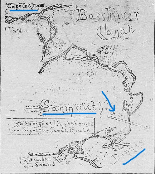
As momentum grew for a canal connecting Buzzards Bay to Cape Cod Bay Thomas Bacon’s Bass River project was continuously pushed down the road. Meetings and petitions were delayed and postponed repeatedly. In December 1891 things seemed to gain traction when civil engineer A.H. Knowles completed a thorough survey of the proposed route including a hand-drawn map.

The 1891 Bass River Canal map. The arrow points to where the Bass River Bridge was.


The Bourne-Sandwich canal was still seen as less feasible which gave the Bass River Canal hope in 1893 when it was yet again submitted as a petition. In June 1894 the Massachusetts House voted in favor of the Bass River Canal, and a year later the company secured a charter. Plans were in place to begin construction which was estimated to last two years and cost between $5-8 million ($176-282 million).

Sadly this is where the project died a death. After four years the charter had been dissolved and no work was ever done on the proposed Bass River Canal. In 1899 the charter for building a canal was granted to the Boston, New York, and Cape Cod Co. which intended to build the canal between Bourne and Sandwich.

For several years after the Bass River Canal Co. attempted to regain their own charter for their canal. Finally in May 1904 the Massachusetts State Senate dealt the company its death blow by flat out rejecting the Bass River Canal proposal. The doorway was open and in 1904 August Belmont purchased and reorganized the Boston, New York, and Cape Cod Co.

Sunset at the Cape Cod Canal.


The rest is history. Work began on the Cape Cod Canal as we know it on June 19, 1909, opening on July 29, 1914. The Bass River Canal idea, much like Jeremiah’s Gutter before it, faded into history. Or did it?

In 1966 rumblings began of a potential look into the feasibility of a Bass River canal. There was even a proposal in February 1966 for $15,000 for a study into whether such a project could be done. However, nothing came from it.

In the end Jeremiah’s Gutter actually was used by boats. The Bass River Canal spent decades locked in legislation before being dissolved without even a spoonful of dirt being shoveled. It is interesting though to think of what Cape Cod would look like today with a Bass River Canal and the Scusset and Manomet Rivers still intact in Bourne and Sandwich.
-------------------------------------------------------------------------

Tuesday, February 9, 2010

In My Footsteps: Trip 20: Yarmouth, Mass.


In My Footsteps
Christopher Setterlund

Trip 20: Yarmouth, Mass.
February 8, 2010
           
            Originally known as Mattacheese by the Native Americans, the town of Yarmouth is rich in history and heritage.  When incorporated by the settlers in 1639 the inhabitants of the town’s borders included the Wampanoag, Cummaquid, Hokanum, and Pawkunnawkut Indian tribes.  One of the first Indian burial grounds sits along Indian Memorial Drive in South Yarmouth and is designated by a collection of large rocks.
Heading east from Hyannis the first place to take in on a tour of historic Yarmouth is the Baxter Grist Mill(left) which is located right on Route 28.  Built in 1710 and named for Thomas Baxter this corn mill is one of several located on Cape Cod.  It was run until around 1900 when electricity and commercial flour became more readily available.  This site at one time had a large outside wooden wheel and was the first site in Yarmouth named to the National Register of Historic Places.  Even though there is a constant rush of traffic going by on Rt. 28 it is still quite easy to imagine the Baxter family grinding their corn for generations before technology made this spot obsolete.  There is a chain link fence surrounding the wooden mill but it is open seasonally for visitors.  The parking area is the next left after passing the mill and one of the original turbines used in the mill sits nearby among the pine trees.
            Continuing along Rt. 28 I passed many motels that have been summer destinations for visitors since the 1950’s; at some points Yarmouth appears as though it has been unchanged for that long as well.  Eventually I came to South Sea Avenue which if taken will lead you to Seagull Beach Road and the similarly named Seagull Beach.  One of the two main beaches on the south side of Yarmouth, Seagull beach is bordered on the east by Parkers River and on the west by the private land of Great Island.  It holds a great view of the boats entering and exiting Barnstable Harbor, the aircraft coming in and leaving the Barnstable Municipal Airport, as well as Lewis Pond which lies on the north side of the parking lot.
            The previously mentioned Parkers River flows in from Nantucket Sound, crosses Rt. 28 and ends up in Seine Pond.  The river runs in between two great family attractions, ZooQuarium, formerly known as the Aqua Circus, and the Pirate’s Cove miniature golf course which actually has two eighteen hole courses.  The best views of the river come on the south side of Rt. 28 on a small parcel of town owned land called Crowes Purchase.  It was once home to a drive-in theater but now affords visitors an easy walk and unobstructed view of the waterfront homes.  The Riverview Resort provides a beautiful view of the river and pier as well as a highly regarded place to stay.  Close by on Rt. 28 is another Cape Cod staple, the Hearth n’ Kettle Restaurant, always a great place to eat.
            Further down Rt. 28 is Seaview Avenue which leads visitors to South Shore Drive and a spectacular row of beaches.  There are Cape Cod staples such as the Red Jacket Resort, Skipper Restaurant, and Ocean Club on Smuggler’s Beach, but this road is most known for the beaches.  The most well known of the beaches has to be Bass River Beach, which is more widely known as Smuggler’s Beach.  The nickname comes from the illegal rum running operations that went on during the Prohibition era.  This was where the alcohol would be smuggled onshore from larger boats via smaller boats and taken to speakeasies. 
            The beach itself has a public boat ramp facing Bass River and a delightful fishing pier(above) stretching over the jetty.  It has a huge parking area and is always filled during the summer months.  Even in the winter months people still flock to this beach to walk or simply enjoy the scenery.  Bass River runs along the beach and is the unofficial border between Dennis and Yarmouth, there is also Crowell Pond located across South Shore Drive.  There is a parking area and a path that will lead you to the water’s edge which is populated by ducks and other water fowl.
            South Shore Drive becomes South Street and leads to another piece of history.  Located on River Street is the Judah Baker windmill(right).  Baker had the mill constructed in 1791 and it was moved several times before finally finding a permanent home on the shores of Bass River.  It was painstakingly renovated by the town in 1999 and now appears as close to its original state as a 200-plus year old windmill can.  The Windmill Park includes a small swimming beach with a rear view of West Dennis Beach.  Much like the Baxter Grist Mill the windmill is open seasonally.
            The last stop I made on this trip was at my old school, the recently closed John Simpkins Elementary(left).  John Simpkins was a Massachusetts Representative who spoke for the people of Cape Cod when he served in the late 1890’s.  The school originally opened in 1930 for all grades but became an elementary school in 1958.  Passing by it on Old Main Street, the building has the look of an old library rather than a school.  There is a large field for recreation as well as a playground for children.  It is the sad process of time that this building that has housed so many growing young minds is no longer needed, but perhaps it will keep on teaching as a possible town library in the future.
            Yarmouth holds both historic sites and recreation areas that rival any others on the Cape.  The beaches are normally the first spot for visitors but the rivers are great for boating and kayaking.  There are many longtime favorite restaurants and motels along Routes 28 and 6A, and other great places waiting to be discovered.  I highly recommend taking your time and seeing all that you can of this, my home town.  Have fun and happy traveling!
Directions:  Baxter Grist Mill: Take Rt. 28 east and turn left onto Mill Pond Rd.  The mill’s parking lot is on the left side.
Seagull Beach: Take Rt. 28 east, turn right onto South Sea Avenue at a set of lights.  Drive ½ mi., turn left onto Seagull Beach Rd.
Smuggler’s Beach: Take Rt. 28 east, bear right onto Old Main Street.  Turn right onto South Street.  Follow it ¾ mi., the beach lot is on the curve on the left side.
Judah Baker Windmill: Take Rt. 28 east, bear right onto Old Main Street.  Turn right onto South Street.  Turn left onto Willow Street.  Windmill is straight ahead at the intersection with River St.
                     A History of the Speakeasy
                     The Ocean Club on Smuggler's Beach
                     Hearth n' Kettle Restaurant