Pages

Showing posts with label main street. Show all posts

Saturday, September 17, 2022

In Their Footsteps: Cape Cod History - The Great Hyannis Fire of 1904


    Natural disasters come in all forms. Hurricanes, tornadoes, blizzards, earthquakes, tsunamis, and more attack without remorse and change land and lives in their wake. Fires are sometimes natural disasters and sometimes man-made. They are no less devastating whatever their origin is.

    Cape Cod has seen its share of fires. There have been some terrible forest fires over the centuries. However what about fires that caused an overwhelming loss of property? One of the deadliest such fires occurred in the first decade of the 20th century and forever changed Downtown Hyannis. This is the story of Main Street’s great fire of 1904.

Looking west down Main Street before the fire. Everything on the right was basically wiped out.


    In the 2020s it’s hard to imagine that there was a time when Hyannis’ Main Street was anything but wall-to-wall shopping and restaurants. A century ago however it was dotted with residential homes as much as businesses. It has always been referred to by its ‘ends.’ The East End lies near the end of the railroad tracks and is close to Cape Cod Hospital, while the West End is today near a rotary and close to the Cape Cod Melody Tent.

    The Main Street area of Hyannis had actually seen a pair of large fires in the preceding years both in 1892 and again in 1894. What came in the early morning hours of December 2-3, 1904 topped both of them in terms of loss.

    The exact location and cause of the fire itself have never truly been established. However, it can be traced to one of two places. Although the fire could have begun at either L.P. Wilson’s grocery store or Walter Baker’s neighboring department store, both located near Center Street across from the railroad depot. It was Wilson who first was made aware of the blaze.

    Living above his store Wilson’s mother alerted him and his wife and two children just before midnight on September 2nd. They were all able to escape the fire in the nick of time with only the clothes on their backs. Wilson’s store was the easternmost location to be lost. Wilson’s mother thought the fire began next door in Baker’s building. However with the buildings all being built so close together, some as close as six feet, it will likely never be known where the actual ignition location was.

    Shortly after midnight on Saturday, December 3rd the alarm had been sounded for the fire department in the form of the bell atop the nearby Universalist Church. It is unknown just how long the flames had been roaring before being brought to anyone’s attention. Wilson’s Hyannis Public Market and Walter Baker’s Department Store were the first structures to go, but they weren’t the last.

    Strong northeast winds coupled with the wooden buildings being so closely packed together meant that the fire spread easily. The flames were essentially blown right down Main Street. Luckily many of the buildings in the path of the flames had items removed by volunteers before the flames could reach them. This included stock from some of the businesses. The Hyannis Fire Department got five pieces of apparatus together but it was no match for the growing fire. Calls were made to other local departments with firefighters from as far away as Middleborough, Provincetown, and Brockton making their way to help. In an extreme act of bravery, a man from the Telephone Exchange Co. was atop a nearby telephone pole sending messages for help as long as he was safe.

    The fire ate through more than 600 feet of Main Street real estate. The exclamation point in the carnage came at just after 3am when the steeple of the Universalist Church came toppling to the ground. A perimeter was set up using wet rugs and blankets on and around buildings that were just out of the fire’s reach. Eventually, the strong northeast winds died down, and by 4am the fire had been contained.

    Heading west along Main Street the following businesses were totally destroyed by the fire: The Universalist Church, post office, Richardson Bros. Photographers, William P. Bearse & Co. who sold meats and provisions, P. F. Campbell & Co. who were tailors, Singer Sewing Machine Co., Charles W Megathlin’s pharmacy, A. P. and E. L. Eagleston’s department store, New England Telephone Exchange, Julia Stevens dressmaker, James E. Baxter boots/shoes, Thomas Nickerson’s marble, and granite works, and finally A. B. Nye & Co.’s paint store.

Postcard of the fire's aftermath, taken by Walter Baker whose department store was destroyed.


    When all was said and done fifteen buildings had been destroyed. Conservative estimates had the damage somewhere in the neighborhood of $150,000($5 million in 2022). For A. B. Nye it was the third time that his paint store had burned down in twelve years. Only once had the fire started on Nye’s property. Sadly sixty-nine-year-old retired sea captain William Penn Lewis died of a heart attack while in the process of saving his house from the fire. As day broke on that Saturday morning all that was left was carnage. Nearly ten acres of property, retail and residential, government and worship, all lay in ruins.

    With the perseverance of a bygone generation, those Hyannis residents who lost their homes or businesses did not stay down for long. In fact, the post office was quickly moved into the home of Mrs. E. C. Benson. Thanks to the determination of Postmaster Percy Goss it was delivering its first shipment of mail by 7:30 that same morning. Most of the businesses quickly set up temporary locations in and around the charred remains of their establishments. Insurance adjusters came later in the day on Saturday, and by the end of the day, plans were already being made for rebuilding Main Street.

Main Street as it appears today. (Google Maps)


    By April 1905 nearly all of the lost buildings had been rebuilt, most of them in the same locations where they previously stood. Today there is little to no reminder of the devastating fire that changed the face of Main Street Hyannis. The ‘new’ buildings are all now nearly 120 years old themselves. They have seen generations of change on Cape Cod and in the world. The solitary reminder in plain sight is a historic marker at the intersection with Ocean Street. It was roughly where the fire was stopped and shows a photo of the aftermath of the blaze.

-----------------------------------------------

Previous Blog Posts:

Be sure to check out my website: Christopher Setterlund.com

Zazzle Store: Cape Cod Living


Sunday, February 6, 2022

Charles Megathlin's Drug Store, Hyannis MA


    In the 21st century pharmacies, much like all of business, are dominated by a few big names. CVS, Walgreens, Rite-Aid, and more are located in nearly every nook and cranny of America. Even supermarkets like Publix and retailers like Walmart dabble in prescriptions. A century ago things were far different. The local pharmacy was a Mom and Pop operation. It was a friendly and familiar face. It was as much a hangout and general store as it was a place to pick up our scripts.

    On Cape Cod there have been many beloved local pharmacies during the 19th and 20th centuries. However one that stands up near the top of the mountain in Cape history is that of Megathlin’s Drug Store. Existing for decades on Hyannis’ Main Street it was the home of operations for Charles W. Megathlin, but it was hardly the only thing he was known for. This is a bit about the man and the business that bore his name.

    Charles W. Megathlin was born in Harwich, Massachusetts on April 2, 1872 to Anthony and Mary Megathlin. While attending Harwich High School Megathlin worked in the drug store of Dr. Benjamin Eldredge. It gave him a taste of what would be his future. After graduating from Harwich High School in 1891 and marrying Louise Munsell in October 1893 the young Megathlin set his sights on a career.

    An opportunity arose in the form of a drug store on Main Street in Hyannis. The 21-year old Megathlin bought the Hyannis Pharmacy from John P. Bowen. Bowen had run the business since 1890 before closing it in October 1893 to take a job in Boston as a traveling salesman.

    Megathlin immediately made improvements, including renaming it to Megathlin’s Drug Store. The grand opening soon thereafter. In order to keep close to his new venture Megathlin rented the former home of Captain Asa Bearse just down the street.

    Pharmacies at the time, much like today, sold far more than just medications. Basic toiletries like soaps and tooth powders, chocolates, and rare gifts and novelties were advertised in the local newspaper as being on sale at Megathlin’s. The business was an immediate success. Within two years it had outgrown its current location.

    Megathlin leased the building across the street in March 1894. This building had been the home of Louis Arenovski’s American Clothing House. Locals had doubts as to whether Megathlin could fill the large space with products. He did so with ease. The next several years saw Megathlin’s Drug Store dominate Hyannis business. It became the go-to for much of the everyday items that locals needed. In 1900 Charles purchased a building owned by William Lewis. This was converted into a new location for the drug store. It appeared as though nothing could slow the growth of Megathlin’s. However an event out of Charles’ control brought everything to a halt.

Postcard image of the Main Street fire. (Sturgis Library)


    On December 10, 1904 a major fire broke out around midnight, engulfing much of the business district of Main Street. The fire raged unchecked for hours. In the end several longtime establishments were damaged or destroyed. These included Megathlin’s Drug Store. In addition the Universalist church, Thomas Nickerson’s marble works, James Baxter’s shoe store, Eagleston’s store, the New England Telephone office, Walter Baker’s department store, and more were lost. Though the fire was said to have been accidental it left much of the east end of Main Street in ruins. Conservative estimates at the time had losses at more than $110,000($3.4 million in 2022)

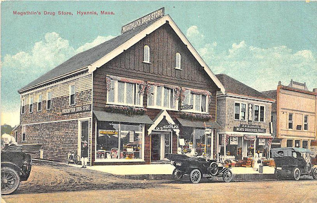
    Charles Megathlin pulled up his boot straps and soldiered on though. Since the fire had been slow burning there had been ample time to remove much of the goods from the store. Megathlin got right to work on rebuilding his popular pharmacy. Within six weeks the new store was partly raised and boarded. In the meantime Megathlin took up temporary residence nearby and sold what dry good he had.

Megathlin's rebuilt store on Main Street(Sturgis Library)


    The new Megathlin’s opened April 20, 1905. He had taken the opportunity to make the new building bigger and better. The improvements included work rooms and laboratory rooms for medications. In addition people came from near and far to see the incredible marble countered soda fountain. The store continued its upward trajectory after the near-tragic fire. The store became an important distraction when Louis died in June 1906 at the young age of forty-one. A year later Charles married Mabel Lumbert.

    It got the point where the Hyannis store was seen on the same level as bigger city stores like those in Boston. More changes came in the summer of 1916. Megathlin added a new staircase to the second floor, mahogany wall cases, and a new drug counter with one hundred drawers. The wise businessman added a Japanese shop and Victrola department on the second floor of the revamped store.

    Decades of faithful service gave Megathlin’s the status as one of the largest local drug store operations in all of New England. It was during this time that Megathlin began to branch out in the grander scheme of the Cape Cod community. His knowledge of business, banking, pharmaceuticals, and more made him a popular local figure. Megathlin’s kind and genial nature only enhanced his stature.

    His new accolades included becoming the President of the New England Association of Rexall Druggists and the President of the Public Safety Committee of Hyannis both in 1917. In 1920 Megathlin added to this by becoming the President of the Cape Cod National Bank of Harwich which later became the Cape Cod Trust Company. His final, and perhaps greatest locally, achievement was becoming the first President of the Cape Cod Chamber of Commerce in February 1921. Megathlin only held that title until the organization’s next meeting which was the next month due to his other obligations.

    Despite having many new responsibilities Megathlin’s first love was his drug store. By the time he got into his mid-50’s though Megathlin was looking to slow down his life a bit with his second wife. In a major event the longtime owner sold Megathlin’s Drug Store to Louis Liggett also of drug store fame. Charles retained ownership of the building including an office he used on the second floor. Despite his name being removed from the business Charles Megathlin was still highly influential. His banking and real estate ventures led the entire building that housed Liggett’s and a few other businesses to be renamed the Megathlin Block later in 1926.

    In a sad irony, only a year after selling his beloved drug store to slow his life down some tragedy struck. Mabel Megathlin died in August 1927 at the age of fifty-seven. In 1928 Charles married for a third time. This was to Marguerite Baldwin. Charles and Marguerite became parents to Charles Jr. in August 1929. Megathlin was fifty-eight at the time and this was his only child.

The historical marker at Ocean St., denoting Megathlin's. (HMdb.org/Brandon D. Cross)


    Although he remained somewhat active locally Charles Megathlin for the most part faded from the public view. He spent the 1930’s and 1940’s enjoying being a husband and father. Charles did end up becoming President of the Cape Cod Chamber for a second time in March 1949. Entering his eighties Megathlin had carved out an extensive legacy on Cape Cod.

    The end came for Charles late on December 2, 1954. During a severe snowstorm Megathlin was driving alone through West Dennis when he lost control and struck a tree. He died instantly.

    Though the final act for Charles Megathlin was that of a tragic accident his life was a rousing success. Through tragic deaths, and the near-total loss of his business, Megathlin and his drug store transcended into iconic status. Even nearly a century after Charles sold his store to Louis Liggett the name Megathlin still echoes along Hyannis’ Main Street.

--------------------------------------------------------------------------

Previous Blog Posts:

Be sure to check out my website: Christopher Setterlund.com

Zazzle Store: Cape Cod Living


Wednesday, October 27, 2010

In My Footsteps: Trip 81: Newport, New Hampshire

In My Footsteps
Christopher Setterlund


Trip 81:  Newport, New Hampshire
September 21, 2010


            Very few things I have seen on my travels so far have been as impressive and breathtaking as my drive through Central New Hampshire.  The mountains are all around you and when it is combined with the oncoming fall foliage it makes for a dreamlike experience.
The Pier Bridge
The amazing view inside the Pier Bridge.
            Newport, New Hampshire, located just west of Mt. Sunapee, is the very definition of a mountain town.  The drive to get there, going through the very well known Sunapee area of New Hampshire, is worthy of an article all its own.  I found it very interesting that despite it being for a totally different reason Newport, New Hampshire was just as beautiful as Newport, Rhode Island.  Where Newport, Rhode Island is beautiful thanks to its mansions and scenic coastline Newport, New Hampshire is beautiful thanks to its covered bridges and scenic mountains.
            First settled in 1763 after a delay due to the hostilities of the French and Indian War, Newport became a very prosperous town thanks to its soil and the Sugar River.  A grist mill and cotton mill were established not too long after but it is a project which never got off the ground that I find most interesting.
South Congregational Church
            In 1817, inspired by the development of the Erie Canal in New York, businessmen suggested that a canal be created between the Connecticut and Merrimack Rivers.  This would have begun at the Sugar River in Newport and would have used Lake Sunapee as a reservoir.  For whatever reason, probably money, this proposed canal project was dropped before the first shovel was plunged into the dirt.  Ironically the Newport-based Sibley Scythe Company, established in 1842, supplied the scythes that were used to clear the jungle away from the site of the Panama Canal when construction began in 1903.    
            The first thing I wanted to see when I arrived in Newport was one of the three covered bridges located within its boundaries.  Even with a GPS these magnificent old relics of a forgotten time were very hard to find.  Luckily two of the bridges were located on the same road, Chandler’s Mill Road.      
            Located a mile down Chandler’s Mill Road is Pier Bridge.  The 216-foot long wooden truss bridge was built in 1907 and crosses over the Sugar River.  It was built to replace a wooden lattice bridge from 1871 which was used by the Sugar River Railroad.  The tracks are no longer there but there is a nice, wide dirt path which will lead to the second bridge, Wright Bridge, less than a mile walk away.
Newport's Town Hall & Court House
            For the Pier Bridge there is a small dirt area where I parked, it is an easy walk to the entrance of the bridge.  I have only seen one other covered bridge and that was in Vermont so standing inside this wooden masterpiece with only the sound of the birds and the soft trickling of the water below was something wonderful.  I truly felt like I was alone in the world during the time I was underneath the shelter of Pier Bridge.  The sunlight trickled in from all sides through the small spaces between boards.  It was something that words won’t do justice to, a photo will do much better.
            I did not choose to walk the .8 miles to the Wright Bridge.  Looking back I should have as my treasure hunt using my GPS led me way off track, I ended up at a point where there were no markings on the GPS screen, only white.  Needless to say after a few drives up and down Chandler’s Mill Road I gave up and headed to my next destination.  Still, I was so happy to get to stand underneath one of only eight covered railroad bridges in the entire country.
            The next stop during my time in Newport consisted of a walk down Main Street.  I parked at the historic South Congregational Church, built in 1823, which stands stoically over the surrounding homes and businesses.  The warm autumn day combined with the colorful leaves made this walk a pleasure, however, the places I got to see on Main Street were in a class of their own.
            There is a saying that the ‘whole is greater than the sum of its parts,’ that is sort of the case with Newport’s Main Street.  Yes there are many historic buildings but the entire scene as I walked along through the peaceful mountain town was something I wanted to capture and take with me when I had to leave.
            There is the beautifully sculpted Golden Eagle, a replica of the eagle crafted by Stephen Hasham of Charlestown, New Hampshire which once sat atop the Eagle Hotel.  It will definitely catch your eye as you pass by as it did for a small group of elementary school students who were out on a field trip on this day.  Sometimes that is how I feel as well.
The awe-inspiring Train Mural on Main Street.
            A few steps away is the mammoth brick Newport Town Hall & Court House built in 1886.  In fact there are several brick buildings, all from around the same time period, 1880’s and 1890’s which stand along Main Street.  The really neat thing about them, and this is the case in other towns I have visited, is that they each have names, usually on a smoky gray background.  I saw the Lewis Block, DeWolf, and Wheeler’s Block as I walked.  I can only assume they were named for those who put up the money to have them built.
            One amazing sight, off the beaten path, along the side of the Johnson Block building is ‘The Train Mural.’  It is an awe-inspiring hand painted depiction of the four seasons of New Hampshire along with some well known sites from the town of Newport.  This is a perfect way to get a taste of what this town is really all about if you do not have the time to walk.  I have been unable to find any information as to how old the Train Mural is, or who painted it, but they deserve great thanks for creating something so beautiful.
             Newport, New Hampshire is every bit as beautiful as its counterpart in Rhode Island.  From the covered railroad bridges to the trip to a simpler time that my walk on Main Street provided it is a town that I will not soon forget.  I hope everyone gets the chance at some point to visit this classic mountain town and to take in all of its beauty; it is worth any length of time to get here.  Have fun and happy traveling!  

     My first book, In My Footsteps: A Cape Cod Travel Guide, is now available at SchifferBooks.com, BarnesandNoble.com, and Amazon.com, soon to be in stores everywhere!  Follow me on Twitter!

Directions:  Pier Bridge:  From I-89 headed north take Exit 12 for Rt. 11.  Turn left at Rt. 11, follow it 11 miles, turn left at N. Main Street.  Take 3rd right onto Rt. 103, follow 3 miles, turn left at Chandler’s Mill Rd., bridge is 1 mile up on right.
            Main Street:  From I-89 headed north take Exit 12 for Rt. 11.  Turn left at Rt. 11, follow it 11 miles, turn left at N. Main Street, there is parking on the right side of street.   

References:  Newport, NH.net
            Newport, NH History.org
           

Tuesday, March 2, 2010

In My Footsteps: Trip 28: Centerville, Osterville, Cotuit, Mass.


In My Footsteps
Christopher Setterlund
Trip 28: Centerville, Osterville, Cotuit, Mass.
February 28, 2010

            Centerville, Osterville, and Cotuit are three small villages considered part of the larger town of Barnstable on the south side of Cape Cod that can easily be passed by on a trip from Falmouth to Hyannis.  Taking you on a trip through Cape history and passing some of the most amazing natural sites as well these three small villages must be seen and appreciated by any traveler to this area.
            Centerville was originally called Chequaquet by the Wampanoag Indians when it was purchased by Myles Standish in 1648.  The village has done a good job of hanging on to its history as Main Street still feels like a walk back through the 19th Century.  The best example of this is the 1856 Country Store(left) located on Main Street.  It has been a general merchandise store since 1856 and still to this day sells homemade jams and jellies as well as classic penny candies that will bring you back to childhood days.  The store now sells its catalog online as it has kept up with technology, but nothing beats taking a walk down Main Street and stopping into the 1856 Country Store.
            For those not looking for trips through history there is the very popular and well known Craigville Beach to visit.   Craigville Beach lies on the similarly named Craigville Beach Road and is bordered on the east by the smaller Covell’s Beach.  It is also bordered on the north by a river flowing in from East Bay; there are many beautiful private homes along the river.  The Kennedy Compound is able to be seen after a long walk on the beach, Craigville Beach is a popular starting and finishing point for many road races and marathons on the Cape and Eastern Massachusetts. 
            Continuing west leads you into Osterville.  There are numerous summer residences here along the beautiful oceanfront and especially in the private Oyster Harbors section of Osterville.  There is a drawbridge connecting Oyster Harbors(below) to the mainland but it is a gated community and thus cannot be accessed by visitors unless they are residents.
            A great place that can be visited by anyone is the Osterville Historic Society Museum located on West Bay Road.  On the grounds sits the Herbert Crosby Boat Shop, it still contains many of the same boat building tools originally used by Mr. Crosby and his family in the mid 19th Century.  The Crosby name is most synonymously associated with the Crosby Catboat which became a hit with sailors not too long after being developed in the latter half of the 19th Century.  The Crosby’s themselves built over 3,000 Catboats from 1850 to 1970.  The Captain Parker House stands closest to the road and was built in 1824.  It belonged to the afore mentioned Captain Parker who like many 19th Century Cape residents made his living on the seas as a fisherman.
There is also an authentic ‘jelly house’ on the grounds.  These were used along road sides mostly prior to World War II to sell all sorts of delicious jams and jellies to travelers.  Once gift shops began selling the same products the houses became obsolete and were sold to individuals.  It is a very unique look into Olde Cape Cod when you stand before this tiny shack that now contains a play set for children.  The grounds can be walked at anytime but the museum itself is open daily from mid-June to mid-September.
The third village of Barnstable to be visited was Cotuit.  As with Centerville and Osterville, a trip down through the Historic District of Main Street will give you a great vision of the town’s past.  Located in the same parking area along Main Street is the Freedom Hall, built in 1860.  There is a marker near the road which is dedicated to the memory of those who first settled the Cotuit area in 1648.  Next door is the Old Meeting House, built in 1846.  It now houses the Masons.
On the opposite side of Main Street sits the Cotuit Library, built in 1874 which sits next to the Cotuit Memorial Park.  There are benches giving a great view of one of the least densely populated areas of the Cape.  Along the roadside sits a stone with a plaque naming all of those Cotuit residents that served in World War I and the two who died during that horrible conflict. 
Directly across from the library and park is Oyster Place.  This short road takes you to the town landing where the dock gives you a tremendous view of Cotuit Bay.  Across the bay, almost straight south is the Col. Charles Codman Estate.  Built in 1870 by John Sturgis, it is part of the National Historic Register.   Col. Codman served in both World Wars and was an aide to Gen. George Patton during World War II.
The last spot to visit ended up being the most spectacular for me.  A little further down Main Street is Oceanview Avenue and Loop Beach.  The road itself is a one-way loop, thus the beach name.  The beach itself is nice but it is the walk back up the hill that is Oceanview Ave. that gives some of the most amazing views on the Cape.  Though mostly dotted with private homes there are still several open patches of landscape allowing for a view of Cotuit Bay, Oyster Harbors, and the Sampson’s Island Sanctuary(left).  It is easy to see why these people chose to live on such a spot.  It capped off a great ride through the western sections of Barnstable.
Barnstable has many small villages; each one has its own share of natural beauty and historical significance.  When the bustle of Rt. 28 and Rt. 132 have overloaded your senses, take a turn down Craigville Beach Road and start your journey through a simpler, quieter section of the Cape.  It is worth the trip.  Have fun and happy traveling!
 Directions:  Craigville Beach: From Rt. 28 heading east, turn right onto Old Stage Road.  Old Stage Rd. becomes Main Street, 1856 Country Store is on the left.  Continue on as Main Street becomes Craigville Beach Rd.  The beach is on the right.
Osterville Historical Museum: From Rt. 28 heading east, turn right onto Old East Osterville Rd.  Follow it to the end and turn right onto Bumps River Rd. bear left onto Pond St.  Follow Pond St. to Main Street.  Turn right at Yachtsman Circle, continue onto Parker Rd.  Turn right at West Bay Rd., Historical Museum is on the left.
Cotuit Memorial Park/Loop Beach: From Rt. 28 heading east, turn right onto Main Street just after end of Rt. 130.  Follow Main Street a mile and a half, Cotuit Library and Memorial Park are on the right.  Continue on about 1,000 feet, Oceanview Avenue is on the left, follow it to Loop Beach.
References:  1856 Country Store
            Osterville Historical Museum
            Mass Audubon - Sampsons Island
            Cotuit Cape Cod.com